It has been a long time since our last posting, so I will try to bring you all up to date. We are currently in Red Bay, AL, awaiting to get some minor repairs on our RV. But first, let me tell you what we have been up to over the last month.
At our last posting, we had just returned to Lyons, Colorado. We were happy to be back to Lyons, tr relax a few days, and to spend some time with my daughter, Debbie and her family. After a few days, we moved the RV up to Estes park, to a privet RV park, just outside Rockey Mountain Notational Park. I stayed at there for a week, but Madeline then left for her annual summer trip to visit her son and his family in Florida. I got a chance to do some hiking in the park, but I am finding it is getting harder and harder to hike, particularly at altitudes much higher than 11,000 feet! nevertheless, I did enjoy the hikes, and it is always exhilarating. after a week up in the mountains, I moved the RV back to Lyons, where I batched for a couple of weeks, awaiting Madeline's return.
My niece, Chindi, came to Colorado to visit for nearly a week, staying with Debbie. We had a wonderful visit and had a chance to take some good hikes. since she was not acclimatized to the altitude, I was able to keep up with her. Our best hike was about six miles to a little lake fed by a waterfall up above the tree-line above the continental divide.
After Chindi left, I had a week to myself (visiting Debbie, of course) until Madeline arrived back from Florida.
More recently we have called Nan, and discovered My sister's , health continues to deteriorate. Nan seems to have her hand full working,, and caring for my sister. We decided to head for Florida. However on the way we encountered electrical problem with the motor home, Mostly involving the lights and turn signals. So we have detoured to Red Bay to get them fixed. They were repaired today, and tomorrow we will continue on to Florida, planning to arrive there late Wednesday.
Monday, September 13, 2010
Thursday, July 29, 2010
Four-Wheeling in Southen Colorado, July 29, 2010
 We have just returned to Lyons, Co from a 3-week stint of four-wheeling in our Jeep in Southern, CO. Our last posting showed pictures of some of the early days of our trip.
I never seemed to get fully acclimatized to the altitude. We were staying at South Fork, and later at Buena Vista at an altitude of 8,000 feet, plus. Most days we were trekking up mountain summits or passes, and eating lunch at altitudes
 of 12, 000 to nearly 14,000
 of 12, 000 to nearly 14,000
 feet --- most days at
about 13, 000 feet. I certainly learned
that I will never be able to hike to these places, so four-wheeling is becoming a way to go to places, I would never be able to go to!
I used to worry that four-wheeling was not environmentally kind. While this is certainly true to some extent, in the west, out here, most of the four-wheel trails are up old roads to mines and ghost towns. The old mines are now revered landmarks, but for sure, the tailings, the acid streams, and hazardous holes in the ground are not
 all that environmentally friendly either!
 all that environmentally friendly either!
The first three photos are of a trip up Bristol Head, a flat topped mountain to the west of Creede. These lava cliffs are on the edge of a huge caldera. The first photo show our Jeeps climbing to the summit. The next of a man "watering"his dog. and the third photo of the surrounding countryside through a gap in the lava.
 The next photo shows what is touted as a natural bridge. It is actually an eroded gap in a lava dike, that has risen above the surrounding countryside. The hard lava dyke has outlasted the softer rock, which it intrude eons ago, and which has eroded away.


Another day we took an interesting ride over Mosquito Pass. This is an old toll road going between Leadville and Alma (Alma is a town near Fairplay.)


Aa we went down the other side of the pass, we found the picturesque remains of the London Mine. The final two pictures are of the mine.
 The next photo shows what is touted as a natural bridge. It is actually an eroded gap in a lava dike, that has risen above the surrounding countryside. The hard lava dyke has outlasted the softer rock, which it intrude eons ago, and which has eroded away.
From the South Fork-Creed area, we moved north to Buena Vista, where we met a new group of friends who like to four-wheel and who also own motor homes.
Buena Vista is the home of the Collegiate Peaks, a series of mountain peaks, many of which are named after Ivy League Colleges , and are over 14,000 feet high. Alas, there is no Mount Cornell.
One trip was up Mount Antero, which, although not named after an Ivy League School, is over 14,000 feet high. The picture of a group of Jeeps parked near a rock pile is at a point near the summit, but not quite there, and at just a few feet under 14,000. The actual summit can be reached by walking over a narrow ridge and making the final climb --- the point at the left of the next picture. In this picture, one can see Pike's Peak, the furthermost mountain --- looking a little hazy in the distance.


Another day we took an interesting ride over Mosquito Pass. This is an old toll road going between Leadville and Alma (Alma is a town near Fairplay.)
The old road goes up to over 13,000 feet, and it was cold up there with remains of many snow banks. We drove through what was the plowed- out portion of a snow drift showed in the next picture.
There were many beautiful flowers up at these high elevations. A picture of one collection of flowers in on a rocky ledge is shown in the next picture. The large white flower is a type of thistle with showy blossoms found at high altitudes. We are told they mostly come out in the evening, so we were lucky too see them. There were also an Alpine version of Spring Beauties, as well as many shades of Indian Paint Brush, and Colorado Columbines.


Aa we went down the other side of the pass, we found the picturesque remains of the London Mine. The final two pictures are of the mine.
Wednesday, July 14, 2010
The Alpine Loop, Colorado
Before I start to relate our adventures, I want to say a few words about my sister, Dona, who is very ill. As some of you know, she is my older sister, is widowed and living in an assisted living facility in Florida. Over time she has gotten weaker and weaker, and is only able get about in a wheel chair. Recently she has been feeling very weak and sleepy. This was finally diagnosed as heart trouble and she had a pacemaker installed. For a short while this seemed to improve her condition, but over the last several weeks she has weakened. She is back in her assisted living home, but she is still desperately ill, and we all fear that she will not recover, but rather succumb to her illness. I love her very much and worry about her. She is quite cheerful, noe she is back in her own room with her own things, and her daughter is keeping a close eye to be sure she is receiving proper care.
 Since our last post,we have left Lyons, CO. Before we left, we took a last look at the eaglet in the nest high in the cliff above our campground in Lyons. the eagle chick has gotten quite large, and we believe it will have fledged, before we return in a month or so. It moves about the nest a can be seen peering over the edge of the nest, as seen in the accompanying photo.
We are now in South Fork, Co --- South Fork so-named for where the

south fork of the Rio Grande joins the

main river that flows in from the west.

are travelling at high altitudes and usually eat our lunch at around 11,000 feet --- where I really find myself moving pretty slowly.

We drove over one pass, Cinnamon Pass" See the photo of Madie getting ready to take a picture. We had lunch at a ghost town, Animas Forks. (See photo.) This used to be the site of mines and stamping mills at one time.
 Since our last post,we have left Lyons, CO. Before we left, we took a last look at the eaglet in the nest high in the cliff above our campground in Lyons. the eagle chick has gotten quite large, and we believe it will have fledged, before we return in a month or so. It moves about the nest a can be seen peering over the edge of the nest, as seen in the accompanying photo.
We are now in South Fork, Co --- South Fork so-named for where the

south fork of the Rio Grande joins the

main river that flows in from the west.
We are at a four-wheeling rally, where we have met many of our friends from our RV club, the Escapees.
The altitude here is 8,200 feet, and I am having a little trouble getting acclimatized. We go four wheeling in the Rockies, mostly following roads that go to abandoned old mines and now defunct mining towns. We frequently

are travelling at high altitudes and usually eat our lunch at around 11,000 feet --- where I really find myself moving pretty slowly.
The accompanying photos are of a trip we took Tuesday around trails known as the Alpine Trail. We drove to Lake City (about 70 miles, from our campground) over on the other side of the Continental Divide

We drove over one pass, Cinnamon Pass" See the photo of Madie getting ready to take a picture. We had lunch at a ghost town, Animas Forks. (See photo.) This used to be the site of mines and stamping mills at one time.
We then continued our journey up over Engineer Pass, which is 12,000 feet in altitude. There are two photos, which give you some idea of the tremendous view we had over the mountains. It seems remarkable to be able to drive to such a place. I know I would never be able to hike any distance at such an altitude.
Tomorrow we go four wheeling up old mining roads up to the Continental Divide, following Rat Creek. What an interesting name!
Monday, June 14, 2010
Kayak Days at Lyons, CO
It has been a cold and rainy weekend here in Lyons. Originally we had planned to go to Rockey Mountain National Park for a week, but it is hard to get a camping spot there, and now it has turned so cold and miserable, we have decide to stay down here at lower elevations, where it is warmer and we have full hook-ups for electric, water and sewage.
Near and in the park here, over the weekend, there was a gathering of kayak enthusiast. Since this is a sport where the participants get soaked, the rainy weather only slowed down the spectators. The creeks and rivers are extremely high here, so the events were moved to areas where the water level was satisfactory.
 On Saturday we drove up the canyon to watch the extreme kayak racers. The rapids there are Class 4 and Class 5, I was told, and I certainly can believe that! There were rapids and falls six to eight feet high, with huge boulders causing "holes" that had to be avoided. Sometimes, a kayak racer did not make it, and was overturned. No one was hurt, but I would think it was very dangerous. The accompanying picture shows one of the racers, successfully navigating a water fall.
The other event was held in the creek that passes through our campground. In this event, the participants paddle into a "hole" below a fall, and do all sort of tricks, such as frontward and do backward somersaults and figure eight maneuvers. The picture here shows one contestant at the beginning of a front somersault.

Tuesday, June 08, 2010
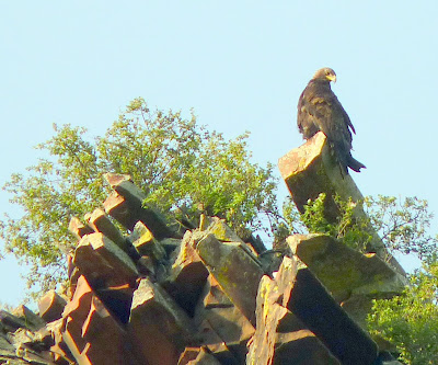
Eagles in Lyons, not a pun

We are now parked in an RV Park in Lyons, CO, a small town about 15 miles from Boulder, where Debbie lives. This town in backed up to the foothill of the Rocky Mountains. So in back of our RV there is a small river or creek flowing, and the roaring rapids can be heard from our open windows. On the other side of the river are tall red cliffs rising up perhaps one hundred feet. These are sandstone cliffs, and obviously are some of the first fold of the plateaus of the Great Plains, that further west become the Rocky Mountains.
We have been entertained over the last week watching a pair of Golden Eagles, tending their chick in a nest built high in he cliffs. The photo shows one of the eagles in the nest with the chick.
The eagles seem to spend an hour or two tending the chick, usually first thing in the morning or late at night.
Sometimes one or both parents will be soaring and then one will suddenly plunge down and with a great fluttering of wings and movement, appear to kill something. Sometimes, whatever, they have killed is returned to the nest, where presumably the chick will eat it.
Other times the eagles will be perched on a nearby pinnacle, or even in another old nearby old eagle's nest, I suppose keeping an eagle eye on things. However, most of the days the parents are gone, living the chick to fend for itself. I have read that the eagles usually lay two eggs. However, the largest chick, usually the one the hatches first, usually kicked its sibling out of the nest.
We have been entertained over the last week watching a pair of Golden Eagles, tending their chick in a nest built high in he cliffs. The photo shows one of the eagles in the nest with the chick.

The eagles seem to spend an hour or two tending the chick, usually first thing in the morning or late at night.
Sometimes one or both parents will be soaring and then one will suddenly plunge down and with a great fluttering of wings and movement, appear to kill something. Sometimes, whatever, they have killed is returned to the nest, where presumably the chick will eat it.
Other times the eagles will be perched on a nearby pinnacle, or even in another old nearby old eagle's nest, I suppose keeping an eagle eye on things. However, most of the days the parents are gone, living the chick to fend for itself. I have read that the eagles usually lay two eggs. However, the largest chick, usually the one the hatches first, usually kicked its sibling out of the nest.
A good question is how does the chick get sufficient water. I suppose it must get enough water from the prey it is fed. Still, these birds must have an amazing biochemical system of water conservation.
We are enjoying our time here. Beside eagle watching, we are spending time with our daughter and her family -- enjoying some time with Katie, who we have not seen for some time. Madeline and I walked the 10K track in the Bolder boulder Memorial Day "Race" ( race? we walked the whole way.) I must say every year this gets harder and harder -- really a little more difficult than I think it should be. Oh well, something to discuss with the MD at the mayo clinic this fall!
We went four-wheeling the other day on a rather difficult and challenging course.
Friday, May 28, 2010
Longmont, CO; May 28, 2010
We left Camp Verde, AZ on Monday and started working our way toward Boulder, CO to attend the Bolder Boulder Memorial Day Celebration.
We stopped at Grants, NM for a day of sight-seeing. We drove south to El Moro National Monument.
 El Moro is a tall sandstone cuesta, a long rock formation - with an uphill slope, ending in a sharp drop-off at one end of cliffs that are perhaps 150-200 feet high. At the base of El Moro there's a nice pool of water, about100 feet in diameter, that never dries up. For this reason travelers, over the years have stopped here to get watter, and rest. this is really an oasis in very dry high desert.
 El Moro is a tall sandstone cuesta, a long rock formation - with an uphill slope, ending in a sharp drop-off at one end of cliffs that are perhaps 150-200 feet high. At the base of El Moro there's a nice pool of water, about100 feet in diameter, that never dries up. For this reason travelers, over the years have stopped here to get watter, and rest. this is really an oasis in very dry high desert.
At the top of El Moro are ruins of an Indian pueblo, that was abandoned around 1400. A small part of the ruins have been reconstructed, as shown in the accompanying photograph. The inhabitants of this structure are thought to be precursors of the Zuni tribe, who now live in a pueblo about 40 miles from El Moro.
 Since this has been a popular stop for travellers, their are numerous petroglyphs and inscriptions on the cliffs. Some of these are ancient Indian petroglyphs, as well as more recent inscriptions by Spanish Conquistadors, American soldiers before and after the Civil War, and many others. The photograph shows a typical piece of graffiti written in Spanish in 1692.

 Since this has been a popular stop for travellers, their are numerous petroglyphs and inscriptions on the cliffs. Some of these are ancient Indian petroglyphs, as well as more recent inscriptions by Spanish Conquistadors, American soldiers before and after the Civil War, and many others. The photograph shows a typical piece of graffiti written in Spanish in 1692.
On the way back to Grants, we stopped at another El Malpais, Spanish for "badlands", another National Monument. This place is for the most part devoted to volcanic geology. There are vast lava fields deposited over thousands of years, the most recent eruption occurring about 2,000 -3,000 years ago. There are volcano tubes to explore, it that is your wont. We did not spend to much time there, as we find lava fields hard to get walk in, and my balance is to unstable to be exploring caves.
The area around the lava fields and cider cones is interesting and quite striking. One interesting feature is a natural arch, shown in the accompanying photo.
From Grants, we drove on and stayed overnight at the top of Raton pass. This pass is of historic interest, as it was one of the more physically trying part of the Santa Fe trail. It was a beautiful place to spend the night.
Today we are in Longmont, CO, and getting ready to celebrate Memorial Day with out daughter, Debbie.
Sunday, May 16, 2010
Camp Verde, AZ, May16, 2010
 It has been over a month since our last posting. It seems to taking more and more of an effort to keep this blog up to date. I am tempted to give it up, and publish only on Face Book. Perhaps I will start publishing commentary here, and send pictures to the Face Book album.
Since our last posting, we left Red Bay, and started working our way west. We stopped at Round Rock, Texas to visit Chris' family. Chris is now a grandfather and of course, I am a great great grandfather, since Meredith had a baby boy. Attached see a photo of a very maternal acting Madeline and Meredith's baby, Jet, regarding each other.

After a few days in round Rock visiting Chris' family, we drove on across Texas. We must have hit it just right for the fields and later the desert was covered with flowers -- bluebells, Indian paintbrush and many other flowers of all colors. I suppose it has been quite wet here recently giving the flowers a chance to bloom. We stopped the first night in a lovely campground in the Texas hill country. We took a walk next to a river, and here you can see a picture of Madeline taking a picture of flowers.
 We stopped for a couple of nights at Lost Dutchman State Park, just outside of Phoenix. This park, one of our favourites, nestled up to the Superstition Mountains, and has some wonderful hiking trails. We did not have time for an extended hike, but did take a little walk in the desert, among the Saguaro cacti --- as shown in the accompanying photo.
 From the Phoenix area, we moved north about 100 miles to Camp Verde, Arizona. Camp Verde is a small town on the Verde river, and a little south of Sedona. This is the famous Red Rock Country, and is one of the most beautiful areas of our country. I really wonder why they dont make it a National Park. This area has everything --- wonderful scenery, good hikes of varying length and level of difficulty, and many trails for ATV and 4-wheeling. Although I have not done it, there is canoeing down the Verde River. This River will become one of the National Wild Rivers. The valley has mountains on the south side and the Mogollon Rim rising on the north side.The Mogollon Rim is an escarpment arising as the edge of the Colorado Plateau. When the Plateau rose, the results were the cliffs and the Red Rocks, and of course, the Colorado River eroding, forming the Grand Canyon.
We have done considerable 4-wheeling in this area in recent days. The photo above shows a view done into the valley, overlooking Sedona.
 There are quite a few ruins of ancient Indian dwelling in this area. These are for the most part multi-storied homes formed in overhanging cliffs ---- the cliff serving as one wall and stones piled with a mud-type mortar making up the other walls. There is usually some rock art --- petroglyphs and pictographs in the same area. The photograph here, shows a a typical site of such ruins. These prehistoric people are thought to be ancestors of the Hopis, and other pueblo-living Indians.
We have taken some exciting trips into the back country. This picture show an Agave the tall stalk or "mast", about four feet high, is used to make tequila. If left alone, this will eventually form flowers and then dry out, ant the plant subsequently dies. We saw these agave, on a jeep trip up in the mountains in high desert to the south of the Verde River Valley.

On this same jeep trip, we stopped to have lunch. A truck hauling a horse trailer drove up. Out of the truck came two cowboys, who got their horses our and started chasing a cow. We knew we were in the West!

We continued that Jeep trip, driving out of the desert into a very rocky canyon. Madeline did all the driving on this trip. The accompanying picture is of Madeline driving the our Jeep up on old river bed in the canyon. Unfortunately on this trip,as went along to drive out of the canyon, the stones and boulders in the river bed got larger and larger. When we had less than a quarter of a mile to go to complete the trip --- the river bed became so rough that we were forced to turn back for a twenty mile return ride on a pretty rough trail. Still the trip was lots of fun.

One day we took a trip up into the mountains near Prescott with our niece, Carmen, and Madeline's brother Carl. After a nice ride and a short hike, we ended up a what is said to be the world's largest Alligator Juniper. This is indeed a huge tree, and it it is almost impossible to get a picture that gives justice to its true size. The picture here shows our neice, Carmen, perched on one of the huge branches.
An interesting thing about this huge tree, is that the branches seem to increase circumference only from the bottom, with the top of the branches eventually becoming bare, with no bark. I looked at other smaller Alligator Junipers, and this seems to be a characteristic of the species --- as the branches age, bark stops growing on the top, and the branches grow from the bottom.

I am not sure if i have ever posted a picture of our home.This photograph of our RV and toad (RV talk for towed vehicle)was taken in Texas, on our way west. You can see two of our four slide-outs extended. These increase the living space by a fair amount.
Saturday, April 10, 2010
Red Bay, Alabama April 10, 2010

Here is a picture of me, my sister, Dona and niece Nan taken on Easter Sunday. We were having a picnic outside of the assisted living home, where Dona lives.
Yesterday we arrived in Red Bay, Alabama so our motor home can have one of it's annual physicals. We have a number of minor repair issues, -- such things as double-pane windows losing their seals and getting foggy, etc. I believe we will be here a week or so.
We know we are moving north; this morning it was about 55 degrees in the coach when we got up. In Florida we would think this was a cold spell. Here it is a nice Spring morning. Spring certainly is here. The red buds are in full bloom as are the dogwoods. Trees are in about a quarter to halfway leafed out.
Last week Madeline finished the remaining of a series of monitoring of her heart. nothing remarkable was found she has a fairly low heart rate, but not dangerously low, and has occasional episodes of spikes in blood pressure, but nothing so extreme to worry about. Her cardiac and circulatory system seems to be in good control --- with the usual advice: lose weight and exercise more.
I bought a new camera today, which should be delivered within a few days. Expect more pictures on this blog in the future!
Sunday, April 04, 2010
Easter, 2010
This is Easter today. We visited my sister, Dona, and had a picnic in an area near the assisted living facility where she lives. Dona's daughter, Nan, was also there with us, so it was a very nice pleasant family get-together.
It is Spring here and it has been obvious since we first arrived a couple of weeks ago. The red buds and dogwoods are in full bloom, as well as the azaleas. Last night we heard spring peepers.
The water situation is interesting. When we first came to this area some ten or so years ago, there was a swamp at the edge of the campground, full of water, with Cyprus trees with their legs in the water. Every year we came back the swamp was receding, to such an extent that last year the poor Cyprus trees were on dry land. Well, just before we left here last year there were a series of rainy days, and I guess they had a wet summer and fall. Now the water level is back to where it was ten years ago! It is amazing how climate cycles, and the actual length of the cycles!
Saturday, March 27, 2010
Back to Northern Florida, March 26
Well, our wintering in at Lake Worth. Florida is over. We had a nice time down there, and enjoyed weather that never got under freezing, and for the most part was up to 60 or 70 degrees every day. More than that, it was wonderful to spend time with out son, his wife, and two children. We were fortunate this year to have Diana and Debbie visit us for a few days, and I got a chance to visit Tom in Virginia for a few days. (That was even more interesting, as they still had quite a bit of snow in Virginia at the time.)
We are back in Bushnell, FL at our Escapees RV park. We are doing a little more medical work, and of course, visiting my sister, who lives in an Assisted Living facility about 25 miles from here. Within a week or two we will move on to Alabama to get some work done on the rig, then work our way to Texas, where we will visit my grandson, great grandchildren, and the latest addition, our great great grandson. We hope then to go on to Big Bend Park, to do a little four wheeling and hiking, but much depends on the weather, and how hot it is getting.
As most of you know, we have a Jeep, now, and we are planning to do a fair amount of 4-wheeling in the deserts and mountains of Colorado. We will be going to one rally with our Escapee friends, and thinking about another one over in Buena Vista, with another group of RVers. So we should have a pretty busy summer.
We have not taken many pictures, lately. I am thinking about buying a camera. I need one with at least 10 times zoom, and an viewer that uses an eyepiece, If anyone has any suggestions, please pass them on.
Wednesday, November 25, 2009
Thanksgiving Eve
Welcome from sunny Florida (although it has been raining yesterday and today).
There is really very little to report, as we have not been traveling to any extent since we arrived. We did go to Boynton Beach for a weekend to see the grandchildren celebrate Halloween. That turned out to be a lot of fun. In South Florida the weather is still quite warm at the end of October, so most folks sit in lawn chairs in front of their house to hand out candy. Some of the homes a well decorated for Halloween, and an occasional place will have a ghost or a witch inside the house, making the kids, ring the doorbell, and then be scared to death, before receiving their treat. I guess in this case the trick is reversed --- the home-owner does the trick!
We have been spending a lot of time just getting our maintenance up to date. We are almost through washing, and waxing. Carpet cleaning is coming up.
We have also spent time getting ourselves maintained. I went to Mayo Clinic for another chest X-ray. Everything is OK, and that will be the end of the monitoring. I also had a few other minor things taken care of. We also went to Tampa to get a tune-up on the cochlear implants, and I must say, I think I am hearing a little better. In a week or two, Madeline will start the process of getting her cataracts removed.
We have purchased a Jeep, planning to do some fairly serious 4-wheeling in the spring. It is second hand, so we are also doing a little fixing up on the vehicle.
That is about the news. We are having Thanksgiving dinner at my niece's home, and my sister Dona will be there. it will be fun to have a little family affair.
Friday, October 23, 2009
Aeroplanes at Rhinebeck Aerodrome and on to SC. Oct 23, 2009
Here are some pictures that Madeline took of the antique airplanes at the Rhinebeck Aerodrome, a museum of the World War I era and before. Many of the airplanes were reconstructions or only had fragments from the original airplane. However, the motors which been rebuilt, are original. I wish I had taken notes, so I could recall the names and origins of all we the airplanes saw, but I did not. The airplane shown below is interesting in that there were controls to twist the wings. This, in conjunction with the rudder, helped the airplane in banking. The original Wright Brothers plane had a similar mechanism. The airplane shown below was taxing, but did not fly. The man walking along the plane is helping to prevent the airplane from becoming airborne, as well as helping it turn, and stop!

The airplane shown below is also an early airplane, when designers were still working on making machines that would fly. This plane also just taxied. Note the skids that worked with the wheels to keep the plane off the ground. The very earliest planes had only skids -- no wheels.

The airplane shown below is also an early airplane, when designers were still working on making machines that would fly. This plane also just taxied. Note the skids that worked with the wheels to keep the plane off the ground. The very earliest planes had only skids -- no wheels.

I believe, although I am a little unsure the airplane below, is a Spade -- a bulwark of the French and British in World War I. This plane did fly during the airshow.
There was also a Sopworth Camel at the aerodrome, but it did not fly. We were told by one of the pilots, it was tricky to fly, because the setting for the spark advance, choke and accelerator,was never the same from flight to flight, and it toke an experienced pilot to adjust all three at once, while trying to gain speed to take off. The Camel also had a rotary engine -- the whole engine rotated with the propeller on a fixed crankshaft. This lead to the development of a huge amount of torque, and could lead to the plane spinning rather than the propeller --- not a good prescription for a long life of the pilot.

After visiting the Aerodrome, we spend a day at Hyde park, visiting Roosevelt's home. I discussed our visit in our previous blog, but suffice to say, if you plan a visit -- consider taking a day and a half to see everything ( introductory film, Presidential Library, Eleanor's Cottage, FDR's getaway cottage, Vanderbilt Mansion). FDR's and Eleanor Roosevelt's grave is shown in the picture below.

We are now in South Carolina, having just completed servicing our RV. We also visited the nearby Kings Mountain National Battlefield, which is in South Carolina, just over the state line from North Carolina. This was the site of an important Revolutionary War battle, in which the Tories (aka Loyalist), loyal to Great Britain, led by British officers were soundly defeated by Americans, mostly who were quickly recruited from backwoodsmen from North Carolina and Virginia.( The American fighter are now called Patriots, in the brochure describing the battle.) This battle was decisive, because it was the end of any loyalist military support from people living in the colonies, for the British. The Loyalist either decided to support the new Revolutionary government or fled to New Brunswick.
There is always something to be learned from the study of past wars. The battle of King Mountain shows how difficult it is , if not impossible, for an invading troops to win a guerrilla war, even with some support and training of the indigenous population. The invaders are essentially getting involved in a Civil War, which they are powerless to control, unless they are willing to engage in genocide. (Nuf' said --End of lesson for today.)
Sunday, October 18, 2009
More Travels, Oct 18, 2009
It has been a while since our last post, so I will try to bring you all up to date. We were disappointed to learn that the the trebuchet practice (Punkin Cunkin) was postponed. Our extended stay to see the event was frustrated. Nevertheless, we enjoyed the extra time in New Hampshire, and had a chance to visit friends and see old sights.
Madeline and I took a pleasant hike through the woods to the old Savage Mill. This is the site of a mill built in the late 1700's or early 1800's, on a stream near, but not on, what is now an abandoned road. The road has been cleared to some extent, for snowmobiles. When I was a kid, living in the area, we used to follow these old roads out in the woods, fairly easily, since most of the original roads were bordered by stone walls. I recalled that we had to leave the old road and traipse off thru the woods, about 400-500 yards, to find the mill. Madeline and I made a number of futile side trips to find the mill. Just when we were ready to give up, I made a last trip into the woods, and there I found the remains of the old mill dam, a line of stone walls about eight feet high. We the found the old walls, where the water wheel must have been. These walls are quite imposing --- two wall, fifteen to twenty feet high and about twelve feet or so apart.
There was a little bridge built across the walls, and a path leading to it -- so obviously there was an easier way, then we took, to get to the old mill. The picture below is of me standing on the little wooden bridge across where the water wheel once stood.
 This was fall in New Hampshire, and the trees were beginning to turn. As one travels through the woods, In wet areas, an occasional tree will be seen all in scarlet or yellow colors.
 On the way back to our car, we saw very colorful mushrooms, growing on old dead trees.
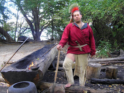
 After the weekend we traveled down to Plymouth Mass, where we visited the Plimoth Plantation. This is a reconstruction of the town of Plymouth as it stood around 1630, approximately 10 years after the Pilgrims arrived. There is also a reconstructed Wampanoag Indian village, a tribe the was present when the settlers first arrive in Plymouth, and helped the early settlers survive during the early years. Indians in the village helped explain how life was in the 1600's. I was interested in the man, shown below making boats out of logs. He said he could complete a boat in about three days.
Below is shown what was a typical Indian dwelling, known to us as a wig warm. it is made of bark attached to lengths of bent saplings, and is quite good, i was told in keeping out snow and rain.

The Plymouth colony has been reconstructed. The village is surrounded with a palisade of logs. The hut have thatched roofs, and the walls are made of a mixture of mud and straw on the inside, and wood on the outside. There were people acting the part some of the colonist, and acting as if they were actually there on a day in 1630. Two interesting characters to me were William Hopkins, and William Bradford. Bradford and I are related, whereas Hopkins and I are not.


We also went to the actual town of Plymouth. There we saw a reconstruction of the Mayflower. The Mayflower was more substantial than I expected, although exceedingly small for the number of passengers. This reconstructed ship at one time actually sailed across the Atlantic Ocean.
Madeline and I took a pleasant hike through the woods to the old Savage Mill. This is the site of a mill built in the late 1700's or early 1800's, on a stream near, but not on, what is now an abandoned road. The road has been cleared to some extent, for snowmobiles. When I was a kid, living in the area, we used to follow these old roads out in the woods, fairly easily, since most of the original roads were bordered by stone walls. I recalled that we had to leave the old road and traipse off thru the woods, about 400-500 yards, to find the mill. Madeline and I made a number of futile side trips to find the mill. Just when we were ready to give up, I made a last trip into the woods, and there I found the remains of the old mill dam, a line of stone walls about eight feet high. We the found the old walls, where the water wheel must have been. These walls are quite imposing --- two wall, fifteen to twenty feet high and about twelve feet or so apart.
There was a little bridge built across the walls, and a path leading to it -- so obviously there was an easier way, then we took, to get to the old mill. The picture below is of me standing on the little wooden bridge across where the water wheel once stood.

 This was fall in New Hampshire, and the trees were beginning to turn. As one travels through the woods, In wet areas, an occasional tree will be seen all in scarlet or yellow colors.
 On the way back to our car, we saw very colorful mushrooms, growing on old dead trees.
 After the weekend we traveled down to Plymouth Mass, where we visited the Plimoth Plantation. This is a reconstruction of the town of Plymouth as it stood around 1630, approximately 10 years after the Pilgrims arrived. There is also a reconstructed Wampanoag Indian village, a tribe the was present when the settlers first arrive in Plymouth, and helped the early settlers survive during the early years. Indians in the village helped explain how life was in the 1600's. I was interested in the man, shown below making boats out of logs. He said he could complete a boat in about three days.
Below is shown what was a typical Indian dwelling, known to us as a wig warm. it is made of bark attached to lengths of bent saplings, and is quite good, i was told in keeping out snow and rain.

The Plymouth colony has been reconstructed. The village is surrounded with a palisade of logs. The hut have thatched roofs, and the walls are made of a mixture of mud and straw on the inside, and wood on the outside. There were people acting the part some of the colonist, and acting as if they were actually there on a day in 1630. Two interesting characters to me were William Hopkins, and William Bradford. Bradford and I are related, whereas Hopkins and I are not.


We also went to the actual town of Plymouth. There we saw a reconstruction of the Mayflower. The Mayflower was more substantial than I expected, although exceedingly small for the number of passengers. This reconstructed ship at one time actually sailed across the Atlantic Ocean.
We also saw Plymouth Rock. I gather the rock is much smaller than originally, and there is some question, if the first settlers actually stepped on it. However, I gather it was a landmark on a long and predominately sandy beach.

From Plymouth we moved on to Upstate New York where we visited Madeline's brothers and their families, and Madeline did genealogical research --- visiting historical societies, libraries and county court houses. While there we rendezvoused with Madeline's brother. who delivered our Jeep that we purchased from a fellow RVer in California.

From Plymouth we moved on to Upstate New York where we visited Madeline's brothers and their families, and Madeline did genealogical research --- visiting historical societies, libraries and county court houses. While there we rendezvoused with Madeline's brother. who delivered our Jeep that we purchased from a fellow RVer in California.
After spending sometime in New York, we traveled to Rhinebeck, a small town down in the Catskills, about 50 miles from New York City. There we visited Rhinebeck Aerodrome, site of a museum of World War I and before, airplanes. We also saw an air show. perhaps i will have some pictures in a future posting. There was an old German tri-plane, the type famously flown by the Red Barron, as well as a Spade, and a Sopworth Camel (the type flown by Snoopy. Most of theses planes as well as others are in flying condition, and indeed were flow, while we were there. there are some older planes also, probably in flying condition, but so primitive, that it is doubtful if it is safe to fly them. some of these were taxied up and down the airfield. It was amusing to learn that some of the airplanes did not have brakes, so two men would have to catch them to stop them and to turn them around.
The next day we visited Franklin Roosevelt's birthplace and home in Hyde Park, New York. There is tour through the home, and then an extensive museum at the Roosevelt national Library. There is also a separate 'cottage" that Eleanor Roosevelt lived in, and another one Franklin built, as "get away".
We are now in Virginia visiting our son and his family. Tomorrow, we move on to the Charlotte, NC area to get repairs and maintenance on our rig.
Wednesday, September 23, 2009
In New Hampshire Again, Sept 3, 2009

We are in Hancock, New Hampshire again.
The leaves are just beginning to change. Around swamps and brooks there are lower story trees. such as grey birches and willows, with lots of red leaves Although there is a lot of color about the bogs and swamps, the setting is usually not conducive to a good photograph. The picture beside this writing, however, gives you an idea of what we see.
Along the roads and at the edges of fields the maples are starting to turn with trees exhibiting scarlet, yellow, and a really beautiful burnt orange (yellowish-red) color. We have delayed leaving for another week, so we should see a better exhibition of color in a few days.

New England is really very picturesque. Nearly every town has a church with a steeple reaching into the sky. One of the more beautiful churches is the old Meeting House/Congregational Church in Hancock, the town in which we are staying.
The building is a combination meeting house and church, and according to a sign next to the church it was built in 1829 and moved in 1854. It is said, that the bell in the tower was cast by Paul Revere.
This combination of church and state, in one form or another, is not too uncommon in New Hampshire towns. In my home town, the town hall was downstairs and the church was upstairs. Te building was owned by the town, and the church rented to the members. Unfortunately, in recent times there has developed animosity between townspeople and the church, and a schism within the church. The members have left the building, so an empty church remains upstairs with a town hall, downstairs used for community functions such as town meetings.

Every town has cemeteries, of course. In New England towns, an old cemetery in the middle of town is a common sight. These are usually kept up fairly well and the old lichen covered marble headstone are quite picturesque. Below I have included a photograph of a cemetery in the center of Hancock.
 We have extended our stay another week. The Yankee Siege is going to start their Trebuchet up on Saturday, practicing in anticipation of the Punkin Chunkin contest. See www.yankeeseige.com.
Subscribe to:
Posts (Atom)