Monday, October 22, 2007

Balloons in New Mexico, October 22, 2007

Last week we attended the Annual Balloon Festival, held in Albuquerque, NM. The festival lasted about two weeks, so we only were there for the last four days. We were there as part of a group activity of our Escapees RV Club, so we had a chance to renew some friendships and make some new ones. Many of the members there were retired people, full timers like us --- so as I like to say, it was nice to meet some adults!

This was really an experience beyond any expectation that I had --- been impressive, but difficult to give justice by either a description or photographs. There were said, to be 800 hot-air balloons participating; but believe me, whatever the number, there were a lot of balloons, of every size and shape.
The first evening there was an event called the “Balloon Glowdeo”. This event was held in the dusk and after dark. The balloonist inflated their baloons, but kept them tethered to the ground. Then periodically they would turn on their propane burners, in such a way that they would emit a bright yellow flame, and illuminate the whole balloon, from the inside. The effect was beautiful and with the funny shaped balloons, interesting. Unfortunately our digital camera doesn’t seem to function well in the dark, so we did not get good photos. Below is one photo, to give you an idea of what I am writing.

The next day there was an event called a mass ascension, where all the balloons filled with hot air, in several waves. The idea was to get all the balloons in the air at one time. At this event we had a chance to see in the air many, what I would call “funny balloons”, actually flying. There were balloons of every description: the Bunny Energizer, a pink elephant, an inflated bank building, a cow, just to mention a few. Below are some pictures of some of the more interesting balloons.


We enjoyed the Balloon Festival, and left after watching the last launching Sunday morning. From Albuquerque, we made our way across the Texas Panhandle, Oklahoma, Arkansas, and Mississippi to Red Bay, Alabama. We are here to get a little work done our RV at the Tiffin factory repair facility. It is mostly minor stuff, but we do want to get the compartment doors that we damaged in the Yukon Territory repaired.

Thursday, October 11, 2007

Across the Painted Desert, Oct. 11, 2007

Yesterday, we crossed part of the Painted Desert driving from Phoenix, AZ to Grants, NM, en route to the Balloon Festival in Albuquerque. While we did not have any adventures, the trip did bring back memories of the many great times I have had in this part of Arizona and New Mexico.

The trip up over the mountain in Arizona between Black Canyon City and Camp Verde is always striking. Once on top of the rise, there is a large plateau with a good view of the mountains to the west and lot of black volcanic rocks interspersed with grass on the high desert. Then we descended into the Verde River Valley, where we have camped several times with friends and with my sister and brother in law. Nearby were the beautiful red rock of Sedona, an interesting town, thought to be near the center of the universe my New Age people. In the National Forest Land here is some of the best area for short hikes in Arizona, with many cliffs, and several natural bridges. There are also some well preserved PreColombian Indian ruins as well as some striking pictographs.

Then the road goes up the Mogollon Rim from the desert of the Verde River Valley to the forested area of Flagstaff where the San Francisco Mountains dominate the scenery. Here we turn west and soon are crossing the Painted Desert. I always want to start humming part of Grafe's "Grand Canyon Suite", when I cross the desert. Yesterday was a nice clear day, so the reds colors of the Painted Desert were particularly striking. As we proceed, we skirt north of Meteor Crater, well-worth a visit, skirt south of First, Second and Third Mesa, home of the Hopi's, and south of Keams Canyon, where our niece teaches in a Navajo School and drive along north of the Petrified Forest National Park --- a park we want to visit again!

Soon we cross the border and are in New Mexico. After going through Gallup, where I attended my first rodeo over sixty years ago, and then drove along the long red mesa, the ranch where my brother's wife lived over seventy-five years ago, and which I visited as a teenager. Then we drove over a long gradually ascending plateau, crossing the Continental Divide, (although the divide looked pretty flat from the road, and soon were here in Grants).

Tuesday, October 09, 2007

Phoenix, and Boron October 9, 2007

We have been in Phoenix, Arizona the last few days. The weather is quite a change from our summer in Alaska. Most days it gets up in the 90's, but cools off nicely during the night. We are visiting our sister-in law, who has had surgery and is quite ill. We nephews and nieces have come to visit her, so we are having a lot of family visiting

I forgot to mention or visit to the village of Boron, California on our way to Phoenix. Boron is the site of a large open-pit borax mine, and also has a small museum devoted mostly to borate. I knew that at one time most of the borate came from the Furnace Creek area of Death Valley,where it was mined, and refined, by dissolving it and re precipitating it, as I recall, and then transported to Mojave, California over the desert in a couple of huge waggons, pulled by the famous Twenty Mule Teams. As I understand it, the borax forms in the dry lake beds in Death Valley, by selectively precipitating from the water, as the lakes slowly evaporate.

What i did not know, was that in California, there are huge underground deposits of boron in several different chemical forms, which have been actively mined for a number of years by underground mines, which have been modified to huge open pit mines. These are said to be the second largest borate deposits in the world -- the largest are in Turkey.

I could learn nothing of the geology of these underground borate deposits, so I don't know why borate type rocks are deposited in such large quantities in just a few parts of the world.

For the chemist among you, boron is an interesting compound. As I recall it forms glasses, similarly to silicon compounds, and I believe it has an interesting chemistry of covalent compounds, similar to carbon. Of course, the most com on everyday use of boron compounds are as cleansers, such as Boraxo, and antiseptics as boric acid.

Unfortunately for me, the museum did not have too much information on the technology of using boron compounds.

We will be here in Phoenix for another day, and then we move to Albuquerque to the Balloon Festival.

Thursday, October 04, 2007

Across the Desert, October 4,007

We spent last week in the Bay Area of California, visiting nieces, grand nieces and grand nephews, as well as a daughter and two grandchildren (who are either in or graduated from college).We also had a lovely diner in our RV with an old schoolmate of Madie’s and his escort. So as you can see we spent a terrific week, just visiting. Then we moved on to Sacramento, where we visited more nephews, nieces, and grand nephews .Lots of fun for us – but perhaps would prefer not to detail the names on a blog.

From Sacramento, we proceeded on a trip to Phoenix. It is still petty hot in the Southwest, so the desert looked ---- well, deserty. I reflected back to 40 to 50 years ago or so, before cars were air conditioned and before the Interstate highways existed. At that time taking an automobile trip West was a big deal --- the sort of thing a man, having made the trip, would take his pictures and put on a presentation at the Rotary Club. In those days, people would stay in a motel day, the day before crossing the desert, and then cross a night when it was cooler. In those days, in the West people carried a canvas bag full of water in front of their car. Water seeping through the canvas, would keep the water cooling. Evaporative cooling in the 1950’s, I guess.

I usually like the desert, but I must admit that after the green forest, clear lakes, and glacier-covered mountain-tops in Alaska and Canada, the desert looks a little scruffy.. Madeline and I both thought that the Mojave Desert, characterized by Joshua Trees, was nowhere as pretty, perhaps even a little ugly, compared to the Sonoran Desert, characterized by Saguaro Cacti.

On our way to Phoenix, we stopped at Lake Havasu City, which is a relatively new city perched in the desert on the shore of a lake formed from a dammed-up Colorado River. One of the important attractions there is London Bridge, which is the original London Bridge ,which was torn down and transported stone by stone to Arizona. For a variety of reasons, we did not get to visit the Bridge until late one very hot afternoon, so we were not in the best of humor. The bridge was much shorter than we expected, and was not particularly impressive. There is said to be an English Village type shopping area under it. We got out of the car looked at the Bridge, but decided we did not feel like shopping, so returned to camp. I had expected to see two towers and lots of shops along the bridge – not so. I guess the Bridge probably seems misplaced in the middle of the desert, when I, at least, was expecting a scene from a Dickens’s novel.

We finally arrived in Phoenix and as I write this, I am in the RV and the RV is in a Freightliner garage, getting oil, filters etc changed.

Friday, September 28, 2007

More Waterfalls then on to CA; Sept 28, 2007

It has been a while since I have made a posting, so I will give what I hope is a brief synopsis of our travels the last several weeks.

We returned from Canada on the fourth of August (Gee, nearly four weeks ago), stopping for a couple of night in Bellingham, Washington, This is a small city on the coast about 15 to 20 miles from the Canadian border. There we met some of our RV friends we have been traveling with on and off and on through our trip to the Yukon and Alaska. For me there was a bit of cultural shock --- getting used to all the traffic, all the people, the preoccupation of TV news on the Iraq War and American politics (sorry to say almost the exact same story with no progress, as when we crossed the border going north ten weeks ago), and distances now stated in miles rather than kilometers. For Madie, there was a great relief to have reliable telephone service to check on the family and grandchildren.

We returned from Canada on the fourth of August (Gee, nearly four weeks ago), stopping for a couple of night in Bellingham, Washington, This is a small city on the coast about 15 to 20 miles from the Canadian border. There we met some of our RV friends we have been traveling with on and off and on through our trip to the Yukon and Alaska. For me there was a bit of cultural shock --- getting used to all the traffic, all the people, the preoccupation of TV news on the Iraq War and American politics (sorry to say almost the exact same story with no progress, as when we crossed the border going north ten weeks ago), and distances now stated in miles rather than kilometers. For Madie, there was a great relief to have reliable telephone service to check on the family and grandchildren.

From Bellingham, we journeyed south and stopped to visit my sister-in-law who resides in an assisted living home in Bainbridge Island, across the strait from Seattle. This necessitated a pleasant ferry ride and a trip down west side of Puget Sound. From there we traveled on to Eugene, Oregon, to visit our relatives, and then on to Bend, Oregon.

Bend, Oregon is on the west side of the Cascade Mountains, about 120 miles west of Eugene. The drive between Eugene is very pretty, up fairly steep mountains, which are covered with dense spruce forest on the east side of the divide. Once you cross over the mountains, there is an obvious climate change, with the west side obviously much dryer. Although the area around Bend is heavily forested, it is obviously dryer.


We went to Bend, Oregon to visit a friend, Paul K, who was one of my mentors during my working life. We had a very nice visit and he showed us the sights around Bend. One day we visited Tumalo Falls, a very pretty water fall, up in the Cascade Mountains, which is the source of Bend’s water supply. See the picture of Paul and me with the waterfall in background.

The following day Paul took us to the Newberry National Volcanic Monument. The Cascades must be relatively new mountains, as there is much evidence of volcanic activity everywhere. As one drives down the highways, one see fairly high cinder cones from old volcanoes, as well as extensive lava beds. The Newberry National Monument features Paullina Peak, whose summit of nearly 8,000 feet overlooks a huge caldera. The peak of the mountain can be reached by a reasonable dirt road. From the peak, one can view two lakes, Paullina and East Lake. See the photo of a view of one of these lakes and the Obsidien Flow, described below.


Photos of chunks of obsidien. The picture is the edge of the flow. These rocks are about one and a half to two feet in diameter.

There is also a view of a lava flow named, Big Obsidian Flow. This is a lava flow with huge chunks of obsidian, a glass that apparently forms when lava cools so quickly, the silica can not crystallize. We drove down to the Obsidian Flow, and hiked on a trail made through it. The obsidian was black in blocks ranging from a few inches many measuring perhaps eight to ten feet on a side. The sides of many of the chunks were sharp. I am told that the material can be knapped, and was used by Native Americans to form arrowheads, spear points and cutting tools. I am sure the obsidian must have been traded by Native Americans, since deposits such as this while not extremely rare, are not to commonly found either. On the way back from Bend, we stopped and looked at Salt Creek Falls. This is a beautiful waterfall, dropping over the edge of an old lava flow into a valley below. See picure.


After our Oregon visits, we went to the Bay area in California, where we visited family. We are now in Sacramento, continuing family visits. Next week we will start toward Albuquerque to attend the Balloon Festival.

Wednesday, September 05, 2007

Prince George and Wells Gray Provincal Park; Sept 4. 2007

We drove into Prince George, BC on Friday Prince George is a small city of about 70,000 that lies just about in the middle of British Columbia. We stayed spent a day there, getting caught up with our shopping, and visiting a manufacturing plant the makes paper pulp.

I should say, before continuing, that Prince George is a center for processing lumber, being pretty much in the middle of the spruce forest of British Columbia. The chief products are lumber (boards and stuff like that) and plywood. However, in making these materials there is a lot of scrap that is made into chips and then into pulp, which is sold to paper companies.

We were able to take a tour of a pulp plant. I won’t go into the details, but only make some observation. The plant was relatively odor free, and not at all like the paper plants I recall that had a disgusting odor that could be perceived twenty miles away. The second interesting thing was the degree of automation. The process of making pulp, in this plant is a continuous one. The whole process is monitored by several people looking at computers. The process runs 24 hours a day, 365 days a year.

There is an amazing amount of recycling and use of waste. Sawdust and bark, which can’t be used for pulp, are used for fuel to help heat the dryers. The digesting liquor is rejuvenated, using quicklime, I think. The limestone is then rejuvenated with kilns.

The final product is paper pulp dried into sheets that could remind you of blotting paper. These sheets are cut in squares of about four feet square, and baled into packages weighing about 500 pounds each. These bales of pulp are the final product sold to paper companies.

The most interesting thing about our visit was the widespread concern expressed by nearly everyone about the pine beetle. The pine beetle is killing just about all the spruce in British Columbia. This is obvious to just a casual observer, driving in the countryside. Acres and acres of dead and dying trees are apparent in many of the forest, and apparently it is spreading. Right now the surplus of dead and dying trees is providing lots of work for the lumber industry, trying to salvage what they can. However the future of the spruce forest is problematic!

It is thought by people here that global warming is causing milder winters. This mean that it does not get cold enough to kill the pine beetles. Of course, people here worry as do people everywhere, that the global warming is irreversible and will get worse.

Monday, September 4

On Saturday we moved on from Prince George, starting to work our way to the US border. We First we headed west toward the Canadian Rockies, and then traveled south in deep valleys that lie between the Canadian Rockies and the Caraboo Mountains. This was a beautiful ride through forest with views of mountains capped with white snow or blue-white glaciers. We stopped overnight in this area, and the next day drove less than one hundred miles to Wells Gray Provincial Park.

Wells Gray Provincial Park is the largest of the Provincial Parks in Canada. It is not well developed, in that most of the park is not accessible to automobile. There is one road that extends about 40 miles into the park, which is probably about one third of the way across the park. The park is especially well known for its waterfalls. Although we have seen lots of very beautiful waterfalls on our trip, we had to admit that those in
The Wells Gray Park were spectacular. Although the pictures do not do them justice, I am including three, to at least give readers an idea of what we experienced.


There is hiking, whitewater rafting, and biking at the park. To get to many of the interesting areas would require backpacking. We will only be in the park for a day and a half, so we only had a chance skim the highlights. Oh yes, we saw a black bear, at the end of our last stop. It was a rather reclusive black bear, so we did not get a very good photo --- but it was a thrill!

Photos of Glacier and Totem Poles, Sept 4, 2007


Here are a couple of photos that would go with previous posting. The totem poles are relatively new and were at the Native American Museum. The glacier is by the road into Stewart, BC and is a particularly beautiful one.

Thursday, August 30, 2007

Hazleton, BC,; 8/29/2007

Yesterday, we drove a short distance from Stewart and are now in Hazleton, BC.

Hazleton is in the middle of several Native American villages, and the site of a reconstructed Gitksan Indian village, Ksan. We visited Ksan yesterday, and the handcrafts exhibited there were quite striking. There are several reconstructed longhouses, which contained exhibits demonstrating their way of life. There were exhibits of dancing paraphernalia, such as rattles, masks, and special robes … all very beautiful and tastefully displayed.

My interest was captivated by totem poles. Yesterday we passed an Indian Village; where there are some of the oldest totem poles in the area, but we somehow missed the turn did not see them. Here at the Ksan Museum, there are several totem poles, carved just for the museum. Today we drove about ten miles to town of Kispiox, where there is a stand of totem poles. These were interesting, because many of the poles had carvings about one-half way to the top, and then usually, but not always something carved on the top. Later we found out that totem poles used to be placed in front of homes, and these poles had actually been moved from their original site.

We made further inquiries and learned a little more. Totem poles are carved horizontally, before they are erected. It takes about two years to carve a pole. The totem poles usually depict a family’s history. The bottom figure represents the clan or present family that has the pole, and the figures above, represents the genealogy of the family, with different figures representing clans of forbearers, with the most ancient ancestors on top. Sometimes there will be figures to represent some event or accomplishment that occurred by the clan’s ancestors.

In former days totem poles were erected in front of a family’s home, but now they are put up just about anywhere. If a totem pole falls, it is not to be moved. There are times when poles fall in a road, and the road has to be moved.

As we travel, we have noticed that every person has a story to tell about themselves, if only you can get them to tell it, and you are willing to listen. I suppose that is why it is so interesting to meet so many people in our wandering type of life-style. My inability to hear these life stories is one of the worse things about my hearing disability.

We are now learning, not does every person have a story to tell, every small town also has a story. Hazleton, BC is no exception. After circulating through the town, and visiting the local historical museum, we learned that Hazleton was once important as a transportation center. It was the head of navigation on the Skeena River, and was regularly supplied by paddle-wheeled steam boats. The Hudson Bay Company received the goods here which in turn were sent into the interior for trading. Hazleton was also the jumping- off place, for a number of small gold rushes in the interior o British Columbia. Later, the telegraph came to Hazleton and the line was continued to Dawson. There was also an ill-stared scheme to extend the telegraph from Canada across the Bering Straits, and on across Asia to Europe. The wire got laid as far as Hazleton, when the whole plan collapses due successful completion of the Atlantic Cable. A warehouse with a huge amount of cable, of now of little value, was abandoned --- well not really abandoned, but given to the Indians, who used it to fashion various types of tools. A northern trans-Canadian railroad route was established, which bypassed Hazleton, and after that the town did not continue to flourish; in fact, a new town, New Hazleton, sprung up near the railroad. Now Old Hazleton is a small village, and I suspect heavily dependent on tourists for its survival.

Tuesday, August 28, 2007

Bears and Glaciers, August 27, 2007

Last week we started our trip down the Cassiar Highway. As I discussed earlier, the Cassiar Highway is the “other” highway running north in western Canada. It parallels the southern half of the Alaska Highway, but is west, closer to the Pacific coastline. This route was considered for the Alaska Highway. But during World War II it was thought to be too close to the coast and subject to Japanese attack.


All except for about 50 miles the Cassiar Highway is paved. However much of the road is quite narrow and winding. This of course makes it a beautiful ride, as long as one is willing to drive slowly, usually about 45 mph, but occasionally much slower. We expected to see a lot of wildlife, but all we saw was one bear cub scurrying across the road. We took our time on the way down, stopping to camp twice in beautiful campgrounds. At one campground we camped next to a lake that was overlooked by mountains. The other campground was in the middle of snowcapped mountains in a beautiful setting.

We are now in Stewart, BC. Stewart is a small town just over the border of the southernmost border of the Alaskan panhandle. About two miles away, just over the border is the town of Hyder, Alaska. Both of these towns are seaports, being on the end of a twenty-mile long fjord, known as the Portland Canal. Apparently many narrow passages, surrounded by mountains are called “canals”, although they are not dug canals, with locks, in the traditional sense of the word.

Steward is a very picturesque little town. To get to the town, one has to travel down a very narrow valley. This valley has very, very steep mountains on its side. These are so steep that at least half of the slopes have been scoured by avalanches. The tops of the mountains are often capped with glaciers, with light blue edges, or pure white snowfields. These glaciers and snowfields give birth to beautiful streams that yield a series of waterfalls, tumbling down the sides of these steep mountains.

Stewart and Hyder were once mining towns, originally for gold, then silver, and later copper. Most of the mines are no longer active, but apparently prospecting continues. I suppose the worldwide escalation of commodity prices, as well as the high price of gold, has made former mining claims, once thought worthless, once again valuable.

Stewart is Canada’s most northern Pacific seaport, which is ice-free year round. This made it a bustling city at one time, but no more. Alaska, of course has several ports, considerably north of Stewart that are ice-free all winter.

The chief reason that we came to Stewart-Hyder was to see the bears. Fish Creek, just outside of Hyder, is a good place for salmon to spawn, and this in turn, draws bears. The bears like to feast on the spawning salmon, and to fatten up in preparation for hibernation. The National Forest Service has built a viewing platform along the creek. The platform is perhaps fifteen to twenty feet above the creek, and extends about one hundred yards along the creek.

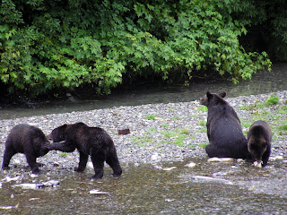
We had been told that the best time to view the bears is early in the morning. So the first day we got up at five am, took a breakfast snack and a carafe of coffee, and drove about one half an hour over to Hyder, Alaska (We are staying in Stewart, BC.) to see the bears. When we arrived, we were told that we had missed a family of a mother and three cubs. We were disappointed, of course, but we went out on the platform. In about five minutes we saw the mother bear coming up the river with her three cubs. We watched these bears for perhaps an hour and a half. The mother bear was fairly serious about fishing. The cubs were interested, but not enough to make more than half hearted attempt to fish. They were a lot like human kids, more interested playing, wrestling and eating berries than catching fish. However, when Momma caught fish, they were there to help eat it, and she seemed willing to share. After a bit, Momma Bear sat down on a gravel bar to rest, and the three cubs played around her – as seen in the accompanying picture.

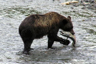
Shortly after the bear with cubs left, another grizzly showed up. He fished awhile, and there is a picture of a bear catching a fish, then he left, and soon another bear showed up – and so it went for several hours. I gather from talking to the ranger, that usually the bears avoid each other, and don’t like to be within sight of each other, so usually we will see just one bear, or a mother with cubs, at a time. There are not always bears at the viewing platform, so sometimes people wait several hours until the bears show up. Early morning and late evening seems to be the best time. We have not seen black bears, only grizzlies. The grizzly bears chase he black bears away. However there are black bears that come around the viewing area. Usually they try to stay in the bushes, and relatively out of sight.


Just this evening we went over to pay a final visit to the bears. We were pleased to see the mother bear and her three cubs again. The cubs entertained us with their antics. Two of the cubs would get on their hind legs, box and cuff each other, then wrestle, until one cub forced the other to the ground and then they would wrestle on the ground. Meanwhile the other cub was lying on his/her back, playing with his/her toes.

Watching the bears is interesting. In the creek the salmon are spawning. The side of the creek is littered with dead “spawned –out” fish. Usually the bears will not eat these, although occasionally they will take a bite or two out of a dead fish, and sometimes, but not often, a bear will eat the dead fish … perhaps these are fish that recently died, and have not spoiled. When the bears fish, they will usually get in the middle of the creek and “herd” the fish upstream or downstream and then lunge in about half the time get a fish. Usually they will take the fish to shore and devour it, eating the skin and the flesh on each side. One bear we saw caught three fish, but threw away the first two after just a couple of bites. We were told that the bears sometimes just want to eat the eggs from the female fish, but I am not sure if this is true.

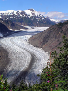
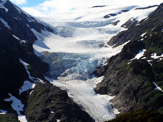
Yesterday we took a drive up a nearby mountain to see the glaciers. There are two important glaciers up there, Salmon Glacier (picture on the left) and Brendan Glacier (picture on the right). It was interesting to see the obvious flow marks in the glacier, and to see that far back, the glacier is on top of mountains. Although this is the middle of August, there are a lot of remains of snow from winter. I doubt if all the snow will be melted, before it begins to snow again.


Fall is definitely in the air here. The temperature frequently gets down into the mid 40’s. On the way down, on the highway, we noted that the shrubs and grasses on the side of the road are turning yellow. Although we are father south, it is certainly obvious, that the nights are getting longer, the days shorter. Here in Stewart, leaves are just beginning to fall. Certainly soon it will be time to go south, and in fact, we will start that way tomorrow morning.

Wednesday, August 22, 2007

On the Road Again, August 21, 2007

On Sunday, we drove up over White Pass, sight-seeing and trying to get a glimpse of the “Dead Horse Trail”, used by the Klondike stampeders. The drive was beautiful, climbing up from sea level to over 5,000 feet in a space of 12 to 15 miles. The road parallels the old trail for the first 5 or 6 miles, and then diverges. We could also get a good view of the narrow gauge railroad bed across the valley.

Once on top of the mountain, on the other side of the pass the country was wild and rough looking tundra, with lots of little ponds and brooks.

On Monday, we broke camp. And again climbed the mountain, and went through the pass eventually to the Yukon Territory. We passed through indescribably beautiful countryside. First, we saw large mountain lakes, five to ten miles long, and a quarter to three quarters miles long, nestled in valleys between high rocky mountains with shear cliffs. As we progressed, the terrain remained the same --- lakes in the shadows of mountains, but the forest of spruce instead of tundra.

Monday night, we are camped in a Provincial Campground, in the woods by a lake. It was beautiful and pleasant to get out in the country away from crowded RV, side by side as we had in the last few campgrounds.

Tuesday we continued down the Alaska Highway to a campground near the Cassiar Highway. The Cassiar Highway is the other road north through British Colombia, to the Yukon Territory, connecting up with the Akaka Highway near the BC-YT border. It runs west of the Alaska Highway, and has a reputation for not being as well maintained. Much of it was gravel until recently, and there is still a 50 mile length of gravel road I hear. We are somewhat apprehensive, as there have been reports that the highway has collapsed in landslides in several places. Local reports are that those have mostly been repaired, and in any event the highway is open all the way.

The Cassiar Highway is said to pass through wild forest and mountains, and we anticipate an adventurous ride, with lots of beautiful scenery.

Fall here is definably in the air. The leaves on shrubs and grass on the side of the road have turned to a golden color. The air is crisp, and evenings are pretty chilly. Pretty soon, Florida is going to sound pretty nice!

Sunday, August 19, 2007

Haines to Skagway, Aug 19, 2007

We put our RV, car and ourselves on the ferry and took a one hour-trip of about 15 miles, going from one branch the fjord where Haines is located, to another branch, where Skagway is located.

Below are a couple of pictures from Haines. First, please see a picture of me in front of the Hammer Museum, which I described in an earlier posting. We thought the huge hammer was pretty interesting!

There are many eagles in Haines, and even more in the winter, so we understand. I believe they winter here because the river flowing into Haines does not freeze, and is a source of fish for the birds. We saw eagles sitting on posts in the harbor, and in trees on the main street.

Haines and Skagway are about the same size, but are very different. An occasional cruise ship stops in Haines -- I think two ships, for a one-day stay, each, when we were there. Skaqway is visited by many cruise ships. There were four in port the day we arrived. Consequently there are surges of tourist in the streets, and many shops opened which cater to tourists. One day the street is crowded, the next day relatively deserted, depending how many cruise ships are in port.

Skagway and the nearby former town of, Dyea (pronounce Dii ee, rhymes with "pie see"), were the beginning of the two major trails over the coastal mountains to Whitehorse, and then by river to the Klondike.

The Chilkoot Trail started in Dyea. In 1898, Dyea had a population of 8,000. In 1903, when the gold rush was over, it had a population of 3. Now the town is gone, and is nothing but cellar holes, rotted timbers and pilings and forest. Nevertheless, the former town is now a National Park, and I suppose is an extension of the Chilkoot Trail National Park. The National Park has an interpretive ranger, who gave us a delightful tour of the old town site. We certainly got a impression of what life must have been like there in the late 1890's.

The Chilkoot Trail, is the trail frequently shown in movies and documentaries. The entire trail is a National Park. The trail was 33 miles, and was the shortest route to Whitehorse and to the Kondike. We started a small hike on the trail (See picture of "Sourdough Dan"). We found he trail started with steep climbing. We wondered how the stampeeders did it, and learned that they usually went in the winter, and traveling was actually easier in the winter. The trail follow a river, and when frozen, the men could pull sleds full of goods on the river ice. The "Scales", the area which has been so frequently photographed of a single file of men carrying their goods on the final trek over Chilkoot Pass, while difficult, is said to have been easier in the winter, because the trail goes over huge boulders, which are covered with snow in the winter. There steps are cut into the ice, upon which the would-be miners trekked up single file.

The miners were required by the Canadian Mounties to carry about a ton of goods, so they could survive a year. They were checked when they crossed the border, at the top of the pass -- the border between Alaska and Canada. This required many trips, caching the supplies, and returning for more. Later, tramways were built, offering the option of ferrying the goods. However, the Chilkoot Trail was the poor man's trail, so many stampeeders carries all their supplies over on their backs, repeating their trips many times.

On our return to Skagway, we saw a bear at the side of the road eating berries. There is a picture here of the bear standing on his back legs. The bears seem to eat an immense amount of leaves, when they eat the berries. We now are getting adept to identifying bear scat on the trail,and can even tell if it is fresh (Caution, Bear Ahead!) or four hours old (Wot, me worry?)

Today we will take the road up to look at White Pass. White Pass is the other Gold Rush route to Whitehorse. White Pass is lower than Chilkoot Pass, the trail longer than the Chilkoot Trail. The trail could be transversed with horses. However, the trail was so steep and narrow, and became so muddy, and the stampeeders in such a hurry, that, it became known as the "Dead Horse Trail". There are many photographs of dead hoses lying along the trail.

Later a railroad was built up over White Pass. While the railroad was completed after the gold rush has subsided, it became for many years the chief route for supplying the Klondike and Dawson City, with good being transported from
Seattle to Skagway by ship, then Skagway to Whitehorse by rail, and the Whitehorse to Dawson city by steamboat on the Yukon River.


Valdez, AK and Haines, AK; posted 8/19/2007

These pictures are somewhat out of the order from which they were taken and and from the events described in the postings.

The first picture shows the edge of a glacier, we saw on our boat trip out of Valdez. You can get an idea of the size of the glacier from the excursion boat floating in front of it.

The next picture show seals on an iceberg, floating next to the glacier. Seals are commonly seen here on almost anything floating out in the water, such as buoys and icebergs.

The next picture is of a black bear (that is really brown, but they are called black bears). Black bears are distinguished from grizzly bears by the absence of a hump.

The ocean picture is of a typical fjord, as seen from a boat. These are beautiful, often the cliffs soar up to snow- or glacier-covered mountains. There are many glacier-fed waterfalls; a typical one is seen on the fjord in the picture.

The next picture is of a grizzly bear. See the hump. This bear is fishing for salmon, but he is a lazy bear, so several times we saw him eating the remains of salmon, that had been filleted by fishermen.

The next picture is of a scenic lighthouse, we saw on our boat trip to Juneau. Finally there is a whale's tail, as he or she dives. They usually reappear again in about six to ten minutes.


On the Road from Dawson City, YT to Eagle, AK; Posted 8/19/2007


The picture below is of the bluffs on the Yukon River at Eagle, Alaska. The town was originally named for the eagles that soared on the bluffs. Note how big and wide the Yukon river is here. It reminds me of the Mississippi,back in the lower 48.

The picture on the right is of fireweed, on an old burn on the road to Eagle. There is a lot of very colorful fireweed up here, but it was especially beautiful on this road.


The picture on the left is of a family of caribou, one of many we saw on the trip to Eagle. Apparently the herd was migrating, an uncommon event in the summer -- probably to escape forest fires. We saw perhaps 7 or 8 groups of animals, ranging from suckling young (yes, we saw one nursing.), yearlings and mature males, and females in groups and also traveling alone.


Bears are always a concern, as you can see in the picture we title, "Bear Paws".

Wednesday, August 15, 2007

Visit to Juneau, AK Aug 15, 2007

Last Sunday we took the ferry from Haines to Juneau, Alaska, where we were met by my cousin Henry. (Henry is the grandson of my Aunt Quack and Uncle Henry.) We left our RV and car in Haines. Juneau is about 50 miles from Haines. Although it is the capital of Alaska, there are no roads to Juneau. One has to get their by airplane or boat! However once you reach Juneau, there is an excellent road system running about twenty miles along the coast and over a bridge to Douglas Island, where my cousin lives.

We saw spectacular scenery on the ride down on the ferry. We were in the Lynn Canal (which seems like a long wide fjord to me, certainly is not a man-made canal) which is the northern part of the Inland Passage. We sailed out of the fjord, in which Haines lies, and sailed down between spectacular mountains, many capped with snow, and with views of various glaciers on the way. We took the “fast ferry” so the ride down took a little over two hours, while the return trip on the regular ferry took four and one-half hours – so you can see this is a very pleasant boat trip and a way to see the spectacular costal scenery of the Inside Passage.

We did a little walking in the forest on Douglas Island, Sunday. The natural growth along the coast is rain forest – not too unlike that seen on the Olympic peninsular in Washington. Juneau usually has over 200 days of rain a year, but we have been very fortunate to have beautiful sunny days on our trip to Juneau, and during most of our stay here in Haines.

The next day after we arrived, we went on a whale-watching trip. We went out on a boat into the bay. We saw several hump backed whales. Mostly we saw their backs, as they lay floating and then a spume of water as they blew (exhaled, I guess). Then we saw their tails as they dove. We were in the midst of a groups of two or three whales, at times within twenty or thirty feet from us. Toward the end of our trip we had a special treat. A baby whale, feeling exuberant, jumped into the air, showing off according to the guide with us. The whale did this three times! It all happened so fast, that Madeline found it impossible to get a picture.

We returned to port. Then Henry took us up to the Mendenhall Glacier. This glacier, which is a National Park, is just a short ways from downtown Juneau. One can easily walk on paved trails to within 150 yards, of the glacier. A large pond full of icebergs is in front of it. Pictures really do not do justice to the view. The glacier front must be fifty to eighty feed high, with a blue cast, but decidedly dirty from all scouring of the mountains. The flow lines in the glacier, as it proceeds down the mountain, are obvious, so one can readily tell that glaciers involve the movement of ice.

The next day we got up early, boarded the “slow” ferry, and had a leisurely ride home. We arrived back at Haines around 1:00 pm. Yesterday afternoon we went to a local museum that is involve with the history of hammers. There are hammers there of every description and designed for every use imaginable, such as hammers used by cobblers, coopers, farriers, blacksmiths, doctors, brewers (to hammer in bungs), carpenters, wood workers, and on and on. It was quite interesting, as are most collections of tools – but a bit overwhelming by the size and complexity of the collection.

Tomorrow we will take the RV and car on the ferry and go to Skagway --- a one-hour trip of about fifteen miles. Skagway and another nearby town, Dyea, were the principle places where the stampedes to Dawson City started during the Klondike Gold Rush. Haines and Valdez, which I have described in earlier blog postings, also had trails to Klondike, but were of far less importance and impact than from Dyea and Skagway.

Sunday, August 12, 2007

Haines, Alaska, Aug 11, 2007

Since I last posted on our blog, we have driven from Valdez to Haines, Alaska. Haines like Valdez is on the coast, but there is not a direct road from Valdez. We had to return to Tok, and then follow the Alaska Highway south into the Yukon Territory, Canada, then turn back southwest again into Alaska. It was not a particularly long trip --- about 450 miles – but we took our time --- five days. After we got to Tok, we traveled over a part of the Alaska Highway that was new to us, so we saw lots of new scenery, characterized by long ranges of mountains, and deep valleys, with large and small lakes. The road was characterized by numerous frost heaves and pot holes, so much of the way we were driving at thirty five miles per hour. We camped in Canadian Provencal Parks three nights. These parks are beautiful, usually near a lake or a creek, and in one case a waterfall, with large and level campsites, but no facilities to speak of --- that is no water, dump stations or electricity, so we were doing good old fashioned camping.

We are really enjoying Haines, Alaska. Haines is a small town at the head of a narrow bay or fjord. Our RV is in a park facing the waterfront. Our view out the front window is the bay is surrounded by high snow capped mountains. The town has been important for fishing and canning and processing salmon. It was also the head of a minor trail to the Klondike during the gold rush, but was not nearly as important as Skagway (which we will visit later this week). Although fishing is still important, the canneries are gone, and the fish are sold to company ships that take them elsewhere for processing. However out in the bay we see many little boats bobbing in the wave with their gill nets out for salmon.

We met some Escapee friend we had traveled with earlier on our trip, and with them we went to a nearby placer gold mine, about twenty miles from town, up in the mountains. The mine is run by an 87-year old gentleman, who was formerly in the lumbering business. He caters to tourists, although it is obvious he is serious about his mining. He is a raconteur, and knows a lot of the local history, so listen to him describe his mine and his early experiences in the lumber business, was as interesting as the gold panning. (Madeline got a few gold flakes, but not enough for us to forego social security checks.)

I visited a salmon canning museum. A local man here became interested in salmon canning, and went about collecting old canning equipment. The equipment probably would have been current in the 1920’s to 1940’s. Most interesting was how the old cans were made. American Can sold a tin-can cylinder which was compressed (folded) into a rectangle. A machine expanded this back into a cylinder. Then another machine crimped a can bottom on. Subsequent machines butchered the fish and placed it into the can and then an additional lid was sealed on.

We have seen bears and eagles around here. At one park, salmon are swimming upstream to spawn. There is a large grizzly bear there just about all the time, either fishing or eating the remains of cleaned fish, left by fishermen. Nearby in the trees we see an occasional eagle, I suppose also fishing. At another park, about 15 miles away, we saw a black bear, harvesting berries. I believe Madeline now has filled her quota of bear pictures.

My cousin, Henry Hopkins lives in Juneau, Alaska – a city about twenty miles from here which can only be reached by boat. Although there are roads in Juneau, they only connect to places near Juneau, but not to any main highway. Juneau is the capital of Alaska, and there is a constant movement to move the capital elsewhere – resisted, of course, by people who live in Juneau. Henry and his family visited us last evening, on route back home from a visit to Fairbanks. Tomorrow we will go down to visit them, and the take a whale-watching trip on Monday. Should be fun.

Tuesday, July 31, 2007

7/31/207, Valdex, Alaska

Hello from Valdez, Alaska. We have had some problems posting pictures on the blog and also sending pictures via Email, so you will not be getting an illustrated travelogue.

We had a pleasant trip to Valdez from Tok. Although it was only 250 miles, sections of the road were very rough, with lots of frost heaves. Also there were stops to admire to admire the spectacular scenery --- lots of mountains streams and quite a few moose wading in the streams. To get to Valdez, it was necessary to cross a costal mountain range, which while not very high (about 5,000 feet), crosses alpine tundra, and very close to a big glacier. From the pass on top of the mountain we descended into a canyon, characterized with rain-forest type foliage and many very beautiful waterfalls.

The first few days we were here were sunny days with a daily shower in the evening or late afternoon. In the morning, the fog would gradually rise over the surrounding mountains, and we would be treated to views of glaciers (nine of them surrounding us) and several waterfalls tumbling down the sides of the mountains, many of them probably fed by high glaciers.

Valdez is an interesting town. The harbor is noted for being one of the most northern harbors that do not freeze. The town was started during the days of the Klondike Gold Rush, the last years of the nineteenth century. An “All American Route" to the Klondike up over the Valdez Glacier (which sits astride a mountain) was proposed as an easy way to transport supplies need to start mining, by pulling them on sleds up and over the mountain. The route was ill-fated. The trip was extremely difficult; would-be miners fell in crevasses, and suffered from the extreme cold. The trip down from the summit on the other side was nearly as difficult as the trip up. Rather than take several days to cross the glacier, it took several weeks. The town started as a point of departure, and later as a refuge for those who did not succeed.

In the 1960’s there was disastrous earthquake in Alaska, and it hit Valdez particularly hard. There were many deaths, and many buildings destroyed. When it came time to rebuild, study showed the “old town” was built on unstable soil, and it was decided to move the whole town (what house that could be moved and rebuilding the rest) to the present town site about four miles away. So mow the present town of Valdez (population of about 1400) is fairly new and modern.

The Alaska pipeline ends near here, across the bay. Of course the harbor is the site of the infamous oil spill from the Exxon Valdez tanker. Although the memory of this mishap is burned into the memory of the residents here, the actual site of the spill is perhaps fifteen miles away beyond the mouth of the harbor. Although the oil spill devastated a large part of the coast of Prince William Sound, much of the sound is still pristine and in good shape.

This is the height of salmon fishing season now. People line up on the shore of the bay and cast a red spoon out into the water. One can see the salmon out in the water, jumping about. Apparently the salmon are schooling in preparation for a run up the creeks to spawn. A daily fishing license costs twenty dollars, and that allows you to keep ten fish. The fish are about a foot long. People in the know say they only keep the female fish, as the flesh of the male fish is a little soft. The fishing seems to take place an hour before to an hour after high tide.

Every little steam, river and creek is full of salmon going upstream to spawn. These fish are turning red, and getting a long under slung jaw. The fish are pretty beaten up, with gashes in the skin. In one place there is a creek leading up to a power plant. A large screen has been placed over the stream to keep the fish from going up and interfering with the plant. The fish are so thick below the screen, one could really walk across them, if they wee not so slippery. Around the edges of the stream, the fish pile on top of each other, attempting to get up the stream. Of course, in a relatively short time all these fish will die. In most streams, I gather, they make it to some point, spawn, guard the eggs a few days, and then die.

We have seen other wild life here. At certain times of day, there are eagles, sitting in trees; I suppose getting ready to fish, when everyone is gone. One morning we saw a bear, out fishing. Madeline, actually saw the beat catch a fish!

We took a boat trip one day, out to see the glaciers and wildlife. The glaciers were a sight to see. The ice was all a light blue. One glacier was sending out a significant amount of icebergs that extended out several miles into the sea.

Tomorrow, we return to Tok. Then we will work our way down to Haines, Alaska, where we will meet some friends, and later visit my cousin Henry, who lives in Juneau

Friday, July 27, 2007

July 26, 2007, Chicken and Eagle

Hello everybody, since our last posting we have gone into Dawson (also known as Dawson City) to see the sights. We visited the town’s historical museum, much of which dealt, as you might guess, with the town’s early gold rush days. There was also a small railroad museum with two locomotives. In the early 1900’s a group of entrepreneurs incorporated a short line, narrow gauge, railroad, developed to serve the miners. All the railroad equipment and locomotives had to be shipped to Dawson from Whitehorse by steam boat, in many cases, disassembled. The railroad was mismanaged from the beginning, but eventually went broke, because the mines mostly became consolidated into several dredging companies, requiring less labor, and a decreasing population.

We visited Jack London’s cabin. Jack London was a relatively unsuccessful miner, whose cabin was originally 40 or 50 miles from Dawson. As a nutritionist I was interested to learn he nearly died from scurvy the final year he spent in the Yukon Territory, losing all his teeth. However he capitalized on his experiences in the Yukon Territory with his many best-selling books, such as “The Call of the Wild”, and short stories, such as “To Build a Fire”. I remember reading his books when I was in my early teens, but I suppose his writing is less popular now, and dated to some extent.

We departed from Dawson, last week, taking a ferry across the Yukon (no bridge) and then over the “Top of the World” Highway. This road is part paved, partly gravel, and partly oiled but in poor repair. We did not find the road as bad as we expected. The stretches through Yukon Territory war largely over alpine tundra, above the tree line. There were spectacular views of mountains on the left and on the right. After crossing the border into Alaska, the road turns to gravel. It is mostly, but not always two lanes wide, the shoulders are very soft due to permafrost, and one needed to know exactly where one’s tires were when meeting an approaching RV or truck, to avoid sinking into the soft shoulder and getting stuck. We spent a fairly leisurely day traveling, and stopped to boondock in a very pleasant BLM campground.

The next day we took our car, and went on a side trip to the small town of Eagle, about sixty miles north, on the Yukon River. As we went on our trip we ascended to a long stretch of road in an area covered with dense brush and aspen trees. We ran into many groups of caribou --- groups consisting of two to perhaps ten animals. There were males, females, and what appeared to be both new born and year-old calves. We later learned that this was an unusual event, seeing a herd this time of year; we were probably seeing a herd, migrating because of forest fires in some area where they usually summer.

The trip to Eagle was over the Forty Mile River area, where much of the gold was discovered prior to the rich strikes in the Klondike. The small towns are gone now, and many of the early roads seemed to have disappeared, so the forest in the valleys is really wilderness now.

Eagle is a pretty little town. At one time it was the center of activity in this part of Alaska. There was an army detachment in a fort, and a custom house, to handle trade between Dawson and Eagle. Eagle was named from eagles that used to soar above the cliffs on the Yukon River. The Yukon is quite wide here, and I will post a photo of the river and the cliffs. We visited the local museum, and got a guided tour through the old courthouse, that contained many artifacts from early days. There is a BLM ranger station supervising the fort of which there are several buildings remaining and area historical site, and helping travelers to the Yukon-Charley River Wilderness. There is also an Indian village nearby, but we did not visit. Madeline asked what people did for shopping for food and clothing. The answer was, they go to Fairbanks twice a year (over two hundred miles away), and depend on gardens for produce in the summer.

We returned to our campsite, and the next day we proceeded down the road, passing by the small town of Chicken. Chicken is an old gold mining town, said to be named “Chicken”, because the original settlers wanted to call it “Ptarmigan”, after the bird, common to the area, but none could spell the word. There is a development called “Beautiful Downtown Chicken” which includes a gift shop, a liquor store, saloon, café, and two outhouses (with the name, on a sign, “chicken poop”. The ceiling of the saloon is lined with hats, with an occasional pair of panties. It is said that the panties can only be put on the ceiling, if they are taken off in front of everyone! That gives you an idea of the level of humor in Chicken ---vulgar, scatological, but funny.

From Chicken, we continued on the road, until we reached the Alaskan Highway, and we drove on a few miles to the town of Tok. We are now in a campground, the Sourdough. There is nightly entertainment – a bluegrass band of the owner and two others, followed, by a pancake tossing contest. Toss a pancake into a bucket, if it goes in, you get a free pancake breakfast. Lots of kidding and lots of fun.

Tomorrow, we go to Valdez (pronounced Valdeez).

Wednesday, July 18, 2007

Dawson City, continued, July 18, 2007

Landscape from the Dempster Highway, en route to the Artic Circle

We drove from Mayo, YT to Dawson City on Friday the 13th. We had a couple of Friday-the-13th misfortunes.

Driving to Dawson, we crossed several places where the road was being repaired, and there were several miles of gravel, rather than paved road. Although we had made plans on how we were going to protect the windshield of our toad (towed car) when we were going over extended lengths of gravel road, somehow, we forgot all our plans and forged ahead. The result was a car windshield with three or four “stars” and three major cracks. We spent the next day trying to repair it with our windshield repair kits, with only fair success. We hope the windshield will hold until we return to the lower 48.

The second misfortune -- when we arrive in Dawson City and were relaxing, Dan’s front tooth, which is a false “pegged” tooth, fell out. The next day he tried to repair that with superglue. It held for about four hours, until he ate a raw carrot. He now looks like Alfred E. Newman.

These are minor mishaps, and we expected some problems would occur on our trip; but we will have lots to do when we get to a place where we can get mechanical and personal repairs.

After getting patched up as best we could, we took a journey on the Dempster Highway to the Artic Circle. The Dempster Highway is a dirt and gravel road that goes from just south of Dawson to Inuvik, a town in the Mackenzie River Delta in the Northwest Territory, about twenty miles from the Beaufort Sea. The entire trip is about 500 miles one way, but we only went about halfway to the Artic Circle. Because of potential road conditions and the lack of services (no gasoline or service station the first 240 miles on a road renowned for sharp shale causing flat tires, (Flat tires on an RV are a major, major problem), we drove our toad and stayed overnight at a motel ( the first motel after 240 miles).

The trip was a bit of an adventure. After traveling about 50 to 80 miles through spruce forest, we emerged upon tundra, which is similar to the alpine tundra in the Rockies in Colorado; only here it occurs at about 5,000 feet. When we got in the tundra area, we went through Oglive Mountains, and across a continental divide separating drainage to the Atlantic Ocean from drainage to the Artic Ocean. The landscape was mostly alpine or perhaps artic tundra, but in areas around rivers and creeks there were a lot of forest, so we were crossing many different types of landscape. After passing through the mountains, we came to long and high hills, with interspersing valleys. There were several types of flowers, but by far the most common was fireweed, the Yukon Territory’s territorial flower. In some stretches fireweed lines the road in a swath, ten to twenty feet wide --- beautiful. (The territorial bird is the raven, of which there are many in the wilderness.)

We stayed overnight in a hotel, and the next day drove about 25 miles to the Artic Circle. As I should have known, but did not, the Artic Circle represents the most southerly point where the sun does not set on the first day of summer (the solstice). As you go north of the Artic Circle, the number of days which the sun does not set in the summer (or come up in the winter) increases.

The temperature was not particularly cold at the Artic Circle, or where we stayed overnight. Perhaps medium-weight-jacket temperature might be the best way to describe it. It did not seem particularly exotic to be there, but when I examined a map, I discovered there are only two places in North America where you can drive past the Artic Circle--- the Dempster Highway in Yukon Territory which we were on, and the Dalton Highway, which follow the pipeline to Prudhoe Bay in Alaska. Labrador for example lies well south of the Artic Circle. So I guess we really are explorers.

We returned to Dawson, where we are still doing touristy things. Our destination was the Klondike and we are here. I found out the Klondike, which refers to the gold bearing area, actually is a river that flows into the Yukon River in Dawson. In turn the gold-bearing creeks flow into the Klondike. The most famous of these creeks was Bonanza. Our campsite is at about the mouth of Bonanza Creek. Bonanza Creek although not a very impressive creek, is perhaps fifteen feet wide and about six to ten inches deep. One could easily wade across it. Yet about ten miles up this creek was the initial discovery of an immense quantity of placer gold, which led to the Klondike Gold Rush.

We visited the site of this first gold discovery yesterday, but there is little to see there, just some trees on a small creek. Up and down the length of the creek, there were huge piles of tailing and mining spoils. In some places an entire hill had been dug up, and mined for placer gold. Much of the creek and the area surrounding our campground was mined with dredges, so many of the buildings are built on piles of gravel remaining from the dredging.

There are still a number of small active placer mines in the area.

Today we will visit some of the local museums and Jack London and Robert Service’s cabin. Later we will be taking the “Top of the World Highway to Chicken, Alaska. This highway has a reputation of being difficult, especially in wet weather, so we will probably wait for a couple of day without rain, before we go.

In earlier pictures, I included a photo Madeline took of a sunset at our campsite here in Dawson. The picture was taken at around midnight1 I had already gone to bed when she took it.

To the Artic Circle, pictures, posted 7/28/2007


This picture of a sunset was taken at about a half hour after midnight. (I was long gone asleep, Madeline stayed up to photograph.


Mother moose and baby moose leaving from a pond, because too many people around.


This is a beautiful picture of the Dempster Highway, lined with fireweed.


Sunday before last, we took a trip up the Dempster highway to the Artic Circle, via the Dempster Highway out of Dawson city.. Above is a picture of me at the Artic Circle. The background shows the terrain, typical of that area -- tundra abd mountains.


Dawson City, YT July 18, 2007


These are pictures were taken at Dawson City, Yukon Territory. The first picture, which looks something like a river boat is actually a large dredge, that was in service from 1913 to the early 1960's. Mining by dredges, operated by large companies replaced many of the small individual placer miners. The dredge worked by pulling up buckets of pay dirt on a continuous chain of iron buckets on the right hand side of the dredge in the picture, processing the gold-containing gravel by sluices inside the dredge, and discarding the tailing to the left. The dredges operated in the bottom of small creeks, digging a pool of water as it removed the pay dirt, and filling the pool behind it with tailings. Thus, although not readily apparent,the dredge was floating in a continuously self-made pool of water. The pay dirt was typically in a band of gravel, ten to twenty feet deep, below a tremendous level of overburden. Much of the work of mining was removing this overburden, which was usually frozen with permafrost. Systems had to be used to melt the permafrost, before it could be removed.
The top picture was taken on top of a high hill (mountain?) overlooking Dawson City. The view is looking up the Yukon River. I wanted to give you an idea how large the Yukon River actually is.

Saturday, July 14, 2007

A Pretty Good Looking Prospector


Good morning, everyone. We have had a little trouble uploading photos, so have been doing it piecemeal.
This prospector panned out two to three flakes of gold, when I took this picture.

Friday, July 13, 2007

Pictures from Mayo, YT; July 13, 2007

Below is a picture of the machine in a placer mine that reduces the volume of gold-containing ore to less than 0.1% of its original volume.


Below is a picture Moont Hildane, which reinds me to some extent of Mount Monadnock.


Mayo, YT; July 12, 2007

For the last two and half days we have been staying at a campground in Mayo, YT and taking day trips to explore. We are in the midst of an area in which there was silver mining area in the first fifty years or so of the twentieth century. The big silver mines were in the little towns of Elsa and Keno City, each of which now have populations of approximately five and twenty. In the silver mining days, silver ore was transported in bags to Mayo, where it was put on steamboats, (not unlike the steamboats that used to ply the Mississippi River) to be transshipped to Whitehorse, eventually ending up in smelters in Seattle. Mayo, once a major river port, now has a population of four or five hundred. About half the citizens belong to First Nation, which is a Canadian term for an Indian tribe. Mayo has a post office, government liquor store and various governmental offices, as well as one restaurant a grocery store, two gas stations and, of all things, a Chinese restaurant.

This area here in many ways is reminiscent of Southern New Hampshire, where I was raised. Many dirt roads in fair repair, lots of lakes (more and bigger than in New Hampshire), lots of gravel and gravel pits. The foliage is mostly aspen and black spruce, not too unlike New Hampshire grey birches and hemlocks. The thing that is most striking to me is that the whole area seems awfully lonesome. You can travel down a road, and you will probably see another car about once every half hour to an hour. When traveling, one rarely sees another house. There are side roads, but not very many of them and you get the feeling that you are about a mile from complete wilderness. The local mountain is Mount Haldane Mountain, which reminds me of our Mount Monadnock. A picture of Mount Haldane is above.

One thing that is different is that the rivers are large, and long. May of the rivers are navigable, and steamboats wee a major form of transportation in the early 1900’s, with many landings, to take on wood. The Yukon is a major river going from Whitehorse, up to Dawson city, and then down through Alaska. On the road to Dawson from Whitehorse, there are many overviews and the Yukon our Mississippi or Missouri River for size and width, and is often in the middle of a very beautiful valley, surrounded by mountains.

Silver mining is pretty much defunct now. There is a little gold mining – more about that later. We are staying at an RV park associated with a motel, neither the RV park or the motel seem very busy. However once or twice a day a helicopter lands in front of us and two or three people get on or off. We discovered that there is exploratory drilling going on out about a 45 minute helicopter trip from here. We are seeing some of the drilling worker leaving or returning from a 12-hour shift. They say the drilling company interested in any minerals they find, and if they find a productive spot, I suppose it will be mined.

What have we been doing? The first day we toured Mayo. This mostly involved going to the visitors Center and learning the history of the area. Yesterday we drove to the two Silver mining towns, Elsa and Keno City. Elsa is closed to the public and people there are protecting the area hoping, I suppose, to be able to open the silver mine some day. Keno City (population about 20) has an interesting museum, mostly dealing either with mining or the past history of the town’s glory days. We ate lunch at the local snack bar (hotdog and potato chips) and then drove up to the top of Keno Hill, the site of the original big silver strike. It was very cold up there. Although there were some interesting hikes we could take, it was just too cold (There was still snow in shaded spots from the winter.) Keno Hill would be a mountain in New Hampshire, about as high as the Pack Monad nocks. We then drove home, Madie stopping to unsuccessfully pan gold.

Today we drove to a placer gold mine. This is a sort of family affair. The mine was started by our guide’s grandfather, and is now run by his father and brother. It sure makes gold mining seem like uncertain and arduous work. Placer mining means that they are mining gold that has deposited in old creek beds, or glacial run-off. Placer mining differs from “hard-rock” mining, because there are no rocks that have to be crushed, etc. Essentially the process involves finding which level of gravel contains the gold (usually the gravel down near bed rock), then removing over-burden until the level containing gold is reached. Then the gold-containing gravel is dumped into a machine, whose name I forget, which is really a classifier. (See picture) It removes the big stones, dumped out one end, then the lighter gravel, comes out each side, until a small amount of pebbles and sand remains, caught on baffles and matting like a door mat, that hopefully contains the gold. This in turn is removed for further classification to get concentrated gold, in another smaller classifier. This final step of concentration takes place about every week and a half, so it takes that long until one is sure they are mining in the right spot. And will have a pay day. A picture of the machine that does the first separation is above.

After this wonderful tour with all this explanation, we (Madeline, I am not that patient) had a chance to pan gold (See picture). Madeline panned out about three flakes. That was pretty good, I think, but she wonders if she should not return the pan for one that recovers more gold.

We are having a wonderful time. Tomorrow, we leave for Dawson City.

Opps! Cant get the pictures upoaded today. I''try again another day.