Yesterday, we drove a short distance from Stewart and are now in Hazleton, BC.
Hazleton is in the middle of several Native American villages, and the site of a reconstructed Gitksan Indian village, Ksan. We visited Ksan yesterday, and the handcrafts exhibited there were quite striking. There are several reconstructed longhouses, which contained exhibits demonstrating their way of life. There were exhibits of dancing paraphernalia, such as rattles, masks, and special robes … all very beautiful and tastefully displayed.
My interest was captivated by totem poles. Yesterday we passed an Indian Village; where there are some of the oldest totem poles in the area, but we somehow missed the turn did not see them. Here at the Ksan Museum, there are several totem poles, carved just for the museum. Today we drove about ten miles to town of Kispiox, where there is a stand of totem poles. These were interesting, because many of the poles had carvings about one-half way to the top, and then usually, but not always something carved on the top. Later we found out that totem poles used to be placed in front of homes, and these poles had actually been moved from their original site.
We made further inquiries and learned a little more. Totem poles are carved horizontally, before they are erected. It takes about two years to carve a pole. The totem poles usually depict a family’s history. The bottom figure represents the clan or present family that has the pole, and the figures above, represents the genealogy of the family, with different figures representing clans of forbearers, with the most ancient ancestors on top. Sometimes there will be figures to represent some event or accomplishment that occurred by the clan’s ancestors.
In former days totem poles were erected in front of a family’s home, but now they are put up just about anywhere. If a totem pole falls, it is not to be moved. There are times when poles fall in a road, and the road has to be moved.
As we travel, we have noticed that every person has a story to tell about themselves, if only you can get them to tell it, and you are willing to listen. I suppose that is why it is so interesting to meet so many people in our wandering type of life-style. My inability to hear these life stories is one of the worse things about my hearing disability.
We are now learning, not does every person have a story to tell, every small town also has a story. Hazleton, BC is no exception. After circulating through the town, and visiting the local historical museum, we learned that Hazleton was once important as a transportation center. It was the head of navigation on the Skeena River, and was regularly supplied by paddle-wheeled steam boats. The Hudson Bay Company received the goods here which in turn were sent into the interior for trading. Hazleton was also the jumping- off place, for a number of small gold rushes in the interior o British Columbia. Later, the telegraph came to Hazleton and the line was continued to Dawson. There was also an ill-stared scheme to extend the telegraph from Canada across the Bering Straits, and on across Asia to Europe. The wire got laid as far as Hazleton, when the whole plan collapses due successful completion of the Atlantic Cable. A warehouse with a huge amount of cable, of now of little value, was abandoned --- well not really abandoned, but given to the Indians, who used it to fashion various types of tools. A northern trans-Canadian railroad route was established, which bypassed Hazleton, and after that the town did not continue to flourish; in fact, a new town, New Hazleton, sprung up near the railroad. Now Old Hazleton is a small village, and I suspect heavily dependent on tourists for its survival.
Thursday, August 30, 2007
Tuesday, August 28, 2007
Bears and Glaciers, August 27, 2007
Last week we started our trip down the Cassiar Highway. As I discussed earlier, the Cassiar Highway is the “other” highway running north in western Canada. It parallels the southern half of the Alaska Highway, but is west, closer to the Pacific coastline. This route was considered for the Alaska Highway. But during World War II it was thought to be too close to the coast and subject to Japanese attack.
All except for about 50 miles the Cassiar Highway is paved. However much of the road is quite narrow and winding. This of course makes it a beautiful ride, as long as one is willing to drive slowly, usually about 45 mph, but occasionally much slower. We expected to see a lot of wildlife, but all we saw was one bear cub scurrying across the road. We took our time on the way down, stopping to camp twice in beautiful campgrounds. At one campground we camped next to a lake that was overlooked by mountains. The other campground was in the middle of snowcapped mountains in a beautiful setting.
We are now in Stewart, BC. Stewart is a small town just over the border of the southernmost border of the Alaskan panhandle. About two miles away, just over the border is the town of Hyder, Alaska. Both of these towns are seaports, being on the end of a twenty-mile long fjord, known as the Portland Canal. Apparently many narrow passages, surrounded by mountains are called “canals”, although they are not dug canals, with locks, in the traditional sense of the word.
Steward is a very picturesque little town. To get to the town, one has to travel down a very narrow valley. This valley has very, very steep mountains on its side. These are so steep that at least half of the slopes have been scoured by avalanches. The tops of the mountains are often capped with glaciers, with light blue edges, or pure white snowfields. These glaciers and snowfields give birth to beautiful streams that yield a series of waterfalls, tumbling down the sides of these steep mountains.
Stewart and Hyder were once mining towns, originally for gold, then silver, and later copper. Most of the mines are no longer active, but apparently prospecting continues. I suppose the worldwide escalation of commodity prices, as well as the high price of gold, has made former mining claims, once thought worthless, once again valuable.
Stewart is Canada’s most northern Pacific seaport, which is ice-free year round. This made it a bustling city at one time, but no more. Alaska, of course has several ports, considerably north of Stewart that are ice-free all winter.
The chief reason that we came to Stewart-Hyder was to see the bears. Fish Creek, just outside of Hyder, is a good place for salmon to spawn, and this in turn, draws bears. The bears like to feast on the spawning salmon, and to fatten up in preparation for hibernation. The National Forest Service has built a viewing platform along the creek. The platform is perhaps fifteen to twenty feet above the creek, and extends about one hundred yards along the creek.
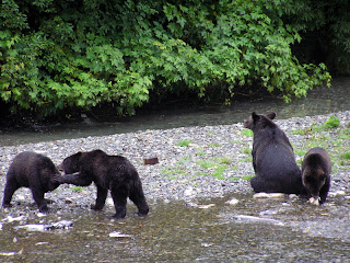
We had been told that the best time to view the bears is early in the morning. So the first day we got up at five am, took a breakfast snack and a carafe of coffee, and drove about one half an hour over to Hyder, Alaska (We are staying in Stewart, BC.) to see the bears. When we arrived, we were told that we had missed a family of a mother and three cubs. We were disappointed, of course, but we went out on the platform. In about five minutes we saw the mother bear coming up the river with her three cubs. We watched these bears for perhaps an hour and a half. The mother bear was fairly serious about fishing. The cubs were interested, but not enough to make more than half hearted attempt to fish. They were a lot like human kids, more interested playing, wrestling and eating berries than catching fish. However, when Momma caught fish, they were there to help eat it, and she seemed willing to share. After a bit, Momma Bear sat down on a gravel bar to rest, and the three cubs played around her – as seen in the accompanying picture.
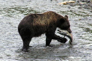
Shortly after the bear with cubs left, another grizzly showed up. He fished awhile, and there is a picture of a bear catching a fish, then he left, and soon another bear showed up – and so it went for several hours. I gather from talking to the ranger, that usually the bears avoid each other, and don’t like to be within sight of each other, so usually we will see just one bear, or a mother with cubs, at a time. There are not always bears at the viewing platform, so sometimes people wait several hours until the bears show up. Early morning and late evening seems to be the best time. We have not seen black bears, only grizzlies. The grizzly bears chase he black bears away. However there are black bears that come around the viewing area. Usually they try to stay in the bushes, and relatively out of sight.
Just this evening we went over to pay a final visit to the bears. We were pleased to see the mother bear and her three cubs again. The cubs entertained us with their antics. Two of the cubs would get on their hind legs, box and cuff each other, then wrestle, until one cub forced the other to the ground and then they would wrestle on the ground. Meanwhile the other cub was lying on his/her back, playing with his/her toes.
Watching the bears is interesting. In the creek the salmon are spawning. The side of the creek is littered with dead “spawned –out” fish. Usually the bears will not eat these, although occasionally they will take a bite or two out of a dead fish, and sometimes, but not often, a bear will eat the dead fish … perhaps these are fish that recently died, and have not spoiled. When the bears fish, they will usually get in the middle of the creek and “herd” the fish upstream or downstream and then lunge in about half the time get a fish. Usually they will take the fish to shore and devour it, eating the skin and the flesh on each side. One bear we saw caught three fish, but threw away the first two after just a couple of bites. We were told that the bears sometimes just want to eat the eggs from the female fish, but I am not sure if this is true.
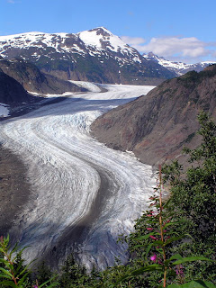
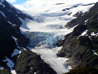
Yesterday we took a drive up a nearby mountain to see the glaciers. There are two important glaciers up there, Salmon Glacier (picture on the left) and Brendan Glacier (picture on the right). It was interesting to see the obvious flow marks in the glacier, and to see that far back, the glacier is on top of mountains. Although this is the middle of August, there are a lot of remains of snow from winter. I doubt if all the snow will be melted, before it begins to snow again.
Fall is definitely in the air here. The temperature frequently gets down into the mid 40’s. On the way down, on the highway, we noted that the shrubs and grasses on the side of the road are turning yellow. Although we are father south, it is certainly obvious, that the nights are getting longer, the days shorter. Here in Stewart, leaves are just beginning to fall. Certainly soon it will be time to go south, and in fact, we will start that way tomorrow morning.
All except for about 50 miles the Cassiar Highway is paved. However much of the road is quite narrow and winding. This of course makes it a beautiful ride, as long as one is willing to drive slowly, usually about 45 mph, but occasionally much slower. We expected to see a lot of wildlife, but all we saw was one bear cub scurrying across the road. We took our time on the way down, stopping to camp twice in beautiful campgrounds. At one campground we camped next to a lake that was overlooked by mountains. The other campground was in the middle of snowcapped mountains in a beautiful setting.
We are now in Stewart, BC. Stewart is a small town just over the border of the southernmost border of the Alaskan panhandle. About two miles away, just over the border is the town of Hyder, Alaska. Both of these towns are seaports, being on the end of a twenty-mile long fjord, known as the Portland Canal. Apparently many narrow passages, surrounded by mountains are called “canals”, although they are not dug canals, with locks, in the traditional sense of the word.
Steward is a very picturesque little town. To get to the town, one has to travel down a very narrow valley. This valley has very, very steep mountains on its side. These are so steep that at least half of the slopes have been scoured by avalanches. The tops of the mountains are often capped with glaciers, with light blue edges, or pure white snowfields. These glaciers and snowfields give birth to beautiful streams that yield a series of waterfalls, tumbling down the sides of these steep mountains.
Stewart and Hyder were once mining towns, originally for gold, then silver, and later copper. Most of the mines are no longer active, but apparently prospecting continues. I suppose the worldwide escalation of commodity prices, as well as the high price of gold, has made former mining claims, once thought worthless, once again valuable.
Stewart is Canada’s most northern Pacific seaport, which is ice-free year round. This made it a bustling city at one time, but no more. Alaska, of course has several ports, considerably north of Stewart that are ice-free all winter.
The chief reason that we came to Stewart-Hyder was to see the bears. Fish Creek, just outside of Hyder, is a good place for salmon to spawn, and this in turn, draws bears. The bears like to feast on the spawning salmon, and to fatten up in preparation for hibernation. The National Forest Service has built a viewing platform along the creek. The platform is perhaps fifteen to twenty feet above the creek, and extends about one hundred yards along the creek.
We had been told that the best time to view the bears is early in the morning. So the first day we got up at five am, took a breakfast snack and a carafe of coffee, and drove about one half an hour over to Hyder, Alaska (We are staying in Stewart, BC.) to see the bears. When we arrived, we were told that we had missed a family of a mother and three cubs. We were disappointed, of course, but we went out on the platform. In about five minutes we saw the mother bear coming up the river with her three cubs. We watched these bears for perhaps an hour and a half. The mother bear was fairly serious about fishing. The cubs were interested, but not enough to make more than half hearted attempt to fish. They were a lot like human kids, more interested playing, wrestling and eating berries than catching fish. However, when Momma caught fish, they were there to help eat it, and she seemed willing to share. After a bit, Momma Bear sat down on a gravel bar to rest, and the three cubs played around her – as seen in the accompanying picture.
Shortly after the bear with cubs left, another grizzly showed up. He fished awhile, and there is a picture of a bear catching a fish, then he left, and soon another bear showed up – and so it went for several hours. I gather from talking to the ranger, that usually the bears avoid each other, and don’t like to be within sight of each other, so usually we will see just one bear, or a mother with cubs, at a time. There are not always bears at the viewing platform, so sometimes people wait several hours until the bears show up. Early morning and late evening seems to be the best time. We have not seen black bears, only grizzlies. The grizzly bears chase he black bears away. However there are black bears that come around the viewing area. Usually they try to stay in the bushes, and relatively out of sight.


Just this evening we went over to pay a final visit to the bears. We were pleased to see the mother bear and her three cubs again. The cubs entertained us with their antics. Two of the cubs would get on their hind legs, box and cuff each other, then wrestle, until one cub forced the other to the ground and then they would wrestle on the ground. Meanwhile the other cub was lying on his/her back, playing with his/her toes.
Watching the bears is interesting. In the creek the salmon are spawning. The side of the creek is littered with dead “spawned –out” fish. Usually the bears will not eat these, although occasionally they will take a bite or two out of a dead fish, and sometimes, but not often, a bear will eat the dead fish … perhaps these are fish that recently died, and have not spoiled. When the bears fish, they will usually get in the middle of the creek and “herd” the fish upstream or downstream and then lunge in about half the time get a fish. Usually they will take the fish to shore and devour it, eating the skin and the flesh on each side. One bear we saw caught three fish, but threw away the first two after just a couple of bites. We were told that the bears sometimes just want to eat the eggs from the female fish, but I am not sure if this is true.
Yesterday we took a drive up a nearby mountain to see the glaciers. There are two important glaciers up there, Salmon Glacier (picture on the left) and Brendan Glacier (picture on the right). It was interesting to see the obvious flow marks in the glacier, and to see that far back, the glacier is on top of mountains. Although this is the middle of August, there are a lot of remains of snow from winter. I doubt if all the snow will be melted, before it begins to snow again.


Fall is definitely in the air here. The temperature frequently gets down into the mid 40’s. On the way down, on the highway, we noted that the shrubs and grasses on the side of the road are turning yellow. Although we are father south, it is certainly obvious, that the nights are getting longer, the days shorter. Here in Stewart, leaves are just beginning to fall. Certainly soon it will be time to go south, and in fact, we will start that way tomorrow morning.
Wednesday, August 22, 2007
On the Road Again, August 21, 2007
On Sunday, we drove up over White Pass, sight-seeing and trying to get a glimpse of the “Dead Horse Trail”, used by the Klondike stampeders. The drive was beautiful, climbing up from sea level to over 5,000 feet in a space of 12 to 15 miles. The road parallels the old trail for the first 5 or 6 miles, and then diverges. We could also get a good view of the narrow gauge railroad bed across the valley.
Once on top of the mountain, on the other side of the pass the country was wild and rough looking tundra, with lots of little ponds and brooks.
On Monday, we broke camp. And again climbed the mountain, and went through the pass eventually to the Yukon Territory. We passed through indescribably beautiful countryside. First, we saw large mountain lakes, five to ten miles long, and a quarter to three quarters miles long, nestled in valleys between high rocky mountains with shear cliffs. As we progressed, the terrain remained the same --- lakes in the shadows of mountains, but the forest of spruce instead of tundra.
Monday night, we are camped in a Provincial Campground, in the woods by a lake. It was beautiful and pleasant to get out in the country away from crowded RV, side by side as we had in the last few campgrounds.
Tuesday we continued down the Alaska Highway to a campground near the Cassiar Highway. The Cassiar Highway is the other road north through British Colombia, to the Yukon Territory, connecting up with the Akaka Highway near the BC-YT border. It runs west of the Alaska Highway, and has a reputation for not being as well maintained. Much of it was gravel until recently, and there is still a 50 mile length of gravel road I hear. We are somewhat apprehensive, as there have been reports that the highway has collapsed in landslides in several places. Local reports are that those have mostly been repaired, and in any event the highway is open all the way.
The Cassiar Highway is said to pass through wild forest and mountains, and we anticipate an adventurous ride, with lots of beautiful scenery.
Fall here is definably in the air. The leaves on shrubs and grass on the side of the road have turned to a golden color. The air is crisp, and evenings are pretty chilly. Pretty soon, Florida is going to sound pretty nice!
Sunday, August 19, 2007
Haines to Skagway, Aug 19, 2007
We put our RV, car and ourselves on the ferry and took a one hour-trip of about 15 miles, going from one branch the fjord where Haines is located, to another branch, where Skagway is located.
Below are a couple of pictures from Haines. First, please see a picture of me in front of the Hammer Museum, which I described in an earlier posting. We thought the huge hammer was pretty interesting!
There are many eagles in Haines, and even more in the winter, so we understand. I believe they winter here because the river flowing into Haines does not freeze, and is a source of fish for the birds. We saw eagles sitting on posts in the harbor, and in trees on the main street.
Haines and Skagway are about the same size, but are very different. An occasional cruise ship stops in Haines -- I think two ships, for a one-day stay, each, when we were there. Skaqway is visited by many cruise ships. There were four in port the day we arrived. Consequently there are surges of tourist in the streets, and many shops opened which cater to tourists. One day the street is crowded, the next day relatively deserted, depending how many cruise ships are in port.
Skagway and the nearby former town of, Dyea (pronounce Dii ee, rhymes with "pie see"), were the beginning of the two major trails over the coastal mountains to Whitehorse, and then by river to the Klondike.
The Chilkoot Trail started in Dyea. In 1898, Dyea had a population of 8,000. In 1903, when the gold rush was over, it had a population of 3. Now the town is gone, and is nothing but cellar holes, rotted timbers and pilings and forest. Nevertheless, the former town is now a National Park, and I suppose is an extension of the Chilkoot Trail National Park. The National Park has an interpretive ranger, who gave us a delightful tour of the old town site. We certainly got a impression of what life must have been like there in the late 1890's.
The Chilkoot Trail, is the trail frequently shown in movies and documentaries. The entire trail is a National Park. The trail was 33 miles, and was the shortest route to Whitehorse and to the Kondike. We started a small hike on the trail (See picture of "Sourdough Dan"). We found he trail started with steep climbing. We wondered how the stampeeders did it, and learned that they usually went in the winter, and traveling was actually easier in the winter. The trail follow a river, and when frozen, the men could pull sleds full of goods on the river ice. The "Scales", the area which has been so frequently photographed of a single file of men carrying their goods on the final trek over Chilkoot Pass, while difficult, is said to have been easier in the winter, because the trail goes over huge boulders, which are covered with snow in the winter. There steps are cut into the ice, upon which the would-be miners trekked up single file.
The miners were required by the Canadian Mounties to carry about a ton of goods, so they could survive a year. They were checked when they crossed the border, at the top of the pass -- the border between Alaska and Canada. This required many trips, caching the supplies, and returning for more. Later, tramways were built, offering the option of ferrying the goods. However, the Chilkoot Trail was the poor man's trail, so many stampeeders carries all their supplies over on their backs, repeating their trips many times.
On our return to Skagway, we saw a bear at the side of the road eating berries. There is a picture here of the bear standing on his back legs. The bears seem to eat an immense amount of leaves, when they eat the berries. We now are getting adept to identifying bear scat on the trail,and can even tell if it is fresh (Caution, Bear Ahead!) or four hours old (Wot, me worry?)
Today we will take the road up to look at White Pass. White Pass is the other Gold Rush route to Whitehorse. White Pass is lower than Chilkoot Pass, the trail longer than the Chilkoot Trail. The trail could be transversed with horses. However, the trail was so steep and narrow, and became so muddy, and the stampeeders in such a hurry, that, it became known as the "Dead Horse Trail". There are many photographs of dead hoses lying along the trail.
Later a railroad was built up over White Pass. While the railroad was completed after the gold rush has subsided, it became for many years the chief route for supplying the Klondike and Dawson City, with good being transported from
Seattle to Skagway by ship, then Skagway to Whitehorse by rail, and the Whitehorse to Dawson city by steamboat on the Yukon River.


Valdez, AK and Haines, AK; posted 8/19/2007
 These pictures are somewhat out of the order from which they were taken and and from the events described in the postings.
The first picture shows the edge of a glacier, we saw on our boat trip out of Valdez. You can get an idea of the size of the glacier from the excursion boat floating in front of it.
The next picture show seals on an iceberg, floating next to the glacier. Seals are commonly seen here on almost anything floating out in the water, such as buoys and icebergs.
The next picture is of a black bear (that is really brown, but they are called black bears). Black bears are distinguished from grizzly bears by the absence of a hump.
The ocean picture is of a typical fjord, as seen from a boat. These are beautiful, often the cliffs soar up to snow- or glacier-covered mountains. There are many glacier-fed waterfalls; a typical one is seen on the fjord in the picture.
The next picture is of a grizzly bear. See the hump. This bear is fishing for salmon, but he is a lazy bear, so several times we saw him eating the remains of salmon, that had been filleted by fishermen.
The next picture is of a scenic lighthouse, we saw on our boat trip to Juneau. Finally there is a whale's tail, as he or she dives. They usually reappear again in about six to ten minutes.


On the Road from Dawson City, YT to Eagle, AK; Posted 8/19/2007

The picture below is of the bluffs on the Yukon River at Eagle, Alaska. The town was originally named for the eagles that soared on the bluffs. Note how big and wide the Yukon river is here. It reminds me of the Mississippi,back in the lower 48.
The picture on the right is of fireweed, on an old burn on the road to Eagle. There is a lot of very colorful fireweed up here, but it was especially beautiful on this road.


The picture on the left is of a family of caribou, one of many we saw on the trip to Eagle. Apparently the herd was migrating, an uncommon event in the summer -- probably to escape forest fires. We saw perhaps 7 or 8 groups of animals, ranging from suckling young (yes, we saw one nursing.), yearlings and mature males, and females in groups and also traveling alone.
Bears are always a concern, as you can see in the picture we title, "Bear Paws".
Wednesday, August 15, 2007
Visit to Juneau, AK Aug 15, 2007
Last Sunday we took the ferry from Haines to Juneau, Alaska, where we were met by my cousin Henry. (Henry is the grandson of my Aunt Quack and Uncle Henry.) We left our RV and car in Haines. Juneau is about 50 miles from Haines. Although it is the capital of Alaska, there are no roads to Juneau. One has to get their by airplane or boat! However once you reach Juneau, there is an excellent road system running about twenty miles along the coast and over a bridge to Douglas Island, where my cousin lives.
We saw spectacular scenery on the ride down on the ferry. We were in the Lynn Canal (which seems like a long wide fjord to me, certainly is not a man-made canal) which is the northern part of the Inland Passage. We sailed out of the fjord, in which Haines lies, and sailed down between spectacular mountains, many capped with snow, and with views of various glaciers on the way. We took the “fast ferry” so the ride down took a little over two hours, while the return trip on the regular ferry took four and one-half hours – so you can see this is a very pleasant boat trip and a way to see the spectacular costal scenery of the Inside Passage.
We did a little walking in the forest on Douglas Island, Sunday. The natural growth along the coast is rain forest – not too unlike that seen on the Olympic peninsular in Washington. Juneau usually has over 200 days of rain a year, but we have been very fortunate to have beautiful sunny days on our trip to Juneau, and during most of our stay here in Haines.
The next day after we arrived, we went on a whale-watching trip. We went out on a boat into the bay. We saw several hump backed whales. Mostly we saw their backs, as they lay floating and then a spume of water as they blew (exhaled, I guess). Then we saw their tails as they dove. We were in the midst of a groups of two or three whales, at times within twenty or thirty feet from us. Toward the end of our trip we had a special treat. A baby whale, feeling exuberant, jumped into the air, showing off according to the guide with us. The whale did this three times! It all happened so fast, that Madeline found it impossible to get a picture.
We returned to port. Then Henry took us up to the Mendenhall Glacier. This glacier, which is a National Park, is just a short ways from downtown Juneau. One can easily walk on paved trails to within 150 yards, of the glacier. A large pond full of icebergs is in front of it. Pictures really do not do justice to the view. The glacier front must be fifty to eighty feed high, with a blue cast, but decidedly dirty from all scouring of the mountains. The flow lines in the glacier, as it proceeds down the mountain, are obvious, so one can readily tell that glaciers involve the movement of ice.
The next day we got up early, boarded the “slow” ferry, and had a leisurely ride home. We arrived back at Haines around 1:00 pm. Yesterday afternoon we went to a local museum that is involve with the history of hammers. There are hammers there of every description and designed for every use imaginable, such as hammers used by cobblers, coopers, farriers, blacksmiths, doctors, brewers (to hammer in bungs), carpenters, wood workers, and on and on. It was quite interesting, as are most collections of tools – but a bit overwhelming by the size and complexity of the collection.
Tomorrow we will take the RV and car on the ferry and go to Skagway --- a one-hour trip of about fifteen miles. Skagway and another nearby town, Dyea, were the principle places where the stampedes to Dawson City started during the Klondike Gold Rush. Haines and Valdez, which I have described in earlier blog postings, also had trails to Klondike, but were of far less importance and impact than from Dyea and Skagway.
Sunday, August 12, 2007
Haines, Alaska, Aug 11, 2007
Since I last posted on our blog, we have driven from Valdez to Haines, Alaska. Haines like Valdez is on the coast, but there is not a direct road from Valdez. We had to return to Tok, and then follow the Alaska Highway south into the Yukon Territory, Canada, then turn back southwest again into Alaska. It was not a particularly long trip --- about 450 miles – but we took our time --- five days. After we got to Tok, we traveled over a part of the Alaska Highway that was new to us, so we saw lots of new scenery, characterized by long ranges of mountains, and deep valleys, with large and small lakes. The road was characterized by numerous frost heaves and pot holes, so much of the way we were driving at thirty five miles per hour. We camped in Canadian Provencal Parks three nights. These parks are beautiful, usually near a lake or a creek, and in one case a waterfall, with large and level campsites, but no facilities to speak of --- that is no water, dump stations or electricity, so we were doing good old fashioned camping.
We are really enjoying Haines, Alaska. Haines is a small town at the head of a narrow bay or fjord. Our RV is in a park facing the waterfront. Our view out the front window is the bay is surrounded by high snow capped mountains. The town has been important for fishing and canning and processing salmon. It was also the head of a minor trail to the Klondike during the gold rush, but was not nearly as important as Skagway (which we will visit later this week). Although fishing is still important, the canneries are gone, and the fish are sold to company ships that take them elsewhere for processing. However out in the bay we see many little boats bobbing in the wave with their gill nets out for salmon.
We met some Escapee friend we had traveled with earlier on our trip, and with them we went to a nearby placer gold mine, about twenty miles from town, up in the mountains. The mine is run by an 87-year old gentleman, who was formerly in the lumbering business. He caters to tourists, although it is obvious he is serious about his mining. He is a raconteur, and knows a lot of the local history, so listen to him describe his mine and his early experiences in the lumber business, was as interesting as the gold panning. (Madeline got a few gold flakes, but not enough for us to forego social security checks.)
I visited a salmon canning museum. A local man here became interested in salmon canning, and went about collecting old canning equipment. The equipment probably would have been current in the 1920’s to 1940’s. Most interesting was how the old cans were made. American Can sold a tin-can cylinder which was compressed (folded) into a rectangle. A machine expanded this back into a cylinder. Then another machine crimped a can bottom on. Subsequent machines butchered the fish and placed it into the can and then an additional lid was sealed on.
We have seen bears and eagles around here. At one park, salmon are swimming upstream to spawn. There is a large grizzly bear there just about all the time, either fishing or eating the remains of cleaned fish, left by fishermen. Nearby in the trees we see an occasional eagle, I suppose also fishing. At another park, about 15 miles away, we saw a black bear, harvesting berries. I believe Madeline now has filled her quota of bear pictures.
My cousin, Henry Hopkins lives in Juneau, Alaska – a city about twenty miles from here which can only be reached by boat. Although there are roads in Juneau, they only connect to places near Juneau, but not to any main highway. Juneau is the capital of Alaska, and there is a constant movement to move the capital elsewhere – resisted, of course, by people who live in Juneau. Henry and his family visited us last evening, on route back home from a visit to Fairbanks. Tomorrow we will go down to visit them, and the take a whale-watching trip on Monday. Should be fun.
Subscribe to:
Posts (Atom)