Friday, April 25, 2008

Cumberland Gap and Flowers Redux; April 25, 2008


Monday we rode up to Cumberland Gap National Historical Park. It was quite interesting to me, because about 45 years ago, on a weekend off, from taking a course on the use of radioisotopes in research at Oak Ridge, our family drove up and through Cumberland Gap.
Pictures: Left, me, standing in the Gap
Right, overlooking the Gap from the pinnacle.

Things have changed a lot in 45 years! (It doesn’t seem that long to me.) In the first place one can drive within thirty miles or so of Cumberland Gap on a four-lane limited- access highway; whereas we had to take curvy mountain roads, at what might be considered a long time ago. But what is most amazing is the Cumberland Gap itself. When we drove there forty five years ago, a very busy, three-lane highway passed through Cumberland Gap, with no place to stop to view and to reflect on the significance of where we were. Now that highway has been eliminated and a tunnel , accommodating four lanes of traffic was constructed in 1995-96. Above the tunnel, the entire Gap has been converted into a wooded park, with only a hiking trail passing through the Gap. Well, actually there is also a railroad track, but it is well hidden. There is also a road to the pinnacle, overlooking the gap with a view of the surrounding area of three states: Kentucky, Tennessee, and Virginia.

A word or two about the historical significance of Cumberland Gap. Cumberland Gap has been an important route for the Indians across the Appalachian Mountains. This chain of mountains was a major impediment to westward migration from the colonies in pre-Revolutionary War Times. Daniel Boone was important explorer of the Kentucky area and frequently used the Cumberland Gap to enter the Kentucky frontier. Later he led a group that blazed the Wilderness Road through the Gap and this became a major thoroughfare for settlers into the Ohio River valley. During the Civil War, the Gap changed hands between the Union and Confederate Armies several times. Although this might have been an important route to supply the Union armies in Eastern Tennessee, generally it proved impractical. The route was too long, and in and weather made the roads too muddy. Livestock were driven over the route, but there was so little forage to consume on the way, the poor animals were nearly starved to death when the arrived at their destination, and hardly fit tobe slaughtered for food.

A few notes on flowers. The iris we had seen and is pictured here is a crested dwarf iris. They stand about five inches off the ground, and have what appears to be three blooms in one, but is actually a single complicated bloom.


The mystery yellow flower turns out to be ragwort. Another picture appears here.


Thursday, April 17, 2008

New (to us) Flowers in Tennessee April 17, 2008


We took a short walk in the woods, behind our RV, yesterday. There are many Spring flowers out, but we saw some that are either new to us or that we can not identify. The most interesting ones are in the photos above. These purple flowers in some ways look like irises. they are purple, but they have three protrusions, or "beards" rather than one we usually see in iris. They look like some type of orchid to me.


The next interesting flowers resemble what we know as "dog-tooth violets", except the leaves are not spotted. I wonder if they are not just a variant. There are two photos of these, below.


We also found a flower, which is new to us. This is called "foamflower" according to a pamphlet we have. The flower reassembles what we in New England call :Wild Lilly of the Valley". The plant is much taller, perhaps seven to ten inches high and the leaves are different than wild lilly of the valley. A picture of a foamflower is above, on the right.

Monday, April 14, 2008

From Tennessee, April 14, 2008


A White Trillium


Several White Trilliums in a Glen


Bloodroot


Yellow Trilliums


Yellow Violets


Violet Violets


We have had a change of plans. Instead of heading west, we decided to stay in the east for a while longer. We are now up at an Escapee RV park in Heiskell, TN, just a little outside of Knoxville and a little more than an hour’s trip to Smoky Mountain National Park. (We decided to change plans, because of the extra mileage of a trip to Phoenix to the Mayo Clinic for some further medical testing required in June, seemed just too expensive in view of the present–day cost of diesel fuel.)

We made the trip from Florida to Tennessee last week. Our daughter, Diana, was on vacation from her school librarian job, so she was able to come to visit us for a few days. We had great fun -- going to the National Park as well as other local attractions.

It is a beautiful time of year here in Tennessee. The spring flowers are coming out. The redbud trees are at their peak here and the dog woods will are just about to come into full bloom. When Diana was here we went to the Smoky Mountains. It was fun to go up the mountains in the car, and stop to look at the flowers. As we gained altitude, there were fewer and fewer flowers, and when we reached the top at some 6000 feet (just a little higher than Denver, so in western parlance, not so high!), nothing was in bloom, and even the trees had not started to bud.

At the lower elevations we saw:
Redbud trees
Dogwood
Purple, white and yellow violets
Flox
White Trilliums
Yellow trilliums
Bloodroot
Fringed Phacelia
Wood anemones
Wild Geraniums


I had never seen yellow trilliums before. They are shaped somewhat like “Johnny Jump Ups, or Wake Robin that we see on Missouri, but are prettier and occasionally you see a plant with the petals fully extended. The White Trilliums were in abundance, and in places an area over about one hundred feet square would be blanketed with them.


The fringed Phacelia was also new to me. These are white flowers with a six delicate fringed petal, - the plant rising perhaps two to three inches off the forest floor, growing where there is sunshine. They were in abidance on the grassy roadside, but they were also seen in the woods.


On another day we all went to visit Museum of the Appalachia, which is Norris, a small town about ten miles from where we are staying. This is a de4lightful museum with many restored buildings, most transported from what were a small isolated Appalachian Villages. There were, of course, a blacksmith shop, an old school, several old barns and an assortment of log cabins. These villages were relatively isolated, and so were pretty self sufficient. They do seem similar to other reconstructed pioneer villages in Indiana, Illinois and Missouri. There was also a large building with a collection of the various tools and household items used one hundred to two hundred years ago. What seems unique to this area is the importance of music. There were a number of exhibits devoted to music, and an obvious pride that many of the pioneers of country music came from the Appalachian region. In that line, there were two musicians performing – one playing the guitar, the other a fiddle.


Well, there seem lots to do here. We have done just a little exploring of the area – visiting one state park and searching out a place that served authentic Tennessee barbeque.

Monday, March 17, 2008

From Northern Florida March 17, 2008

Since my last posting we have moved from the Lake Worth area in Southern Florida to Northern Florida. We have not had many adventures – doing more mundane things such as getting our yearly physical at the Mayo Clinic, with the usual attendant collection of body fluids, poking and scanning, and waiting for the next appointment. (The Mayo Clinic is a little unusual in that they try to get you your full range of exams – actual physical exam, blood collection, X-ray and CAT scan if needed; eye exam and heavens know what else, within a few days.) Anyway, the final reading seems to be that as we get older, parts wear out, and more pills are needed to compensate. Still, all in all, we seem to be pretty healthy – feeling good, with just a few things that need to be periodically monitored.
Before going to Jacksonville to the Mayo Clinic, we stopped off at Lazy Days RV Park near Tampa, and refreshed our driving skills with a driving lesson. We had taken one there several years ago, but seem to be a little hazy on how to best set the mirrors and how most easily to back into parking spots. We had a nice session. The 40 foot coach we now have seems to handle differently from the 37 foot coach we had before. I believe the wheel base is longer. At any rate, things we had learned to do instinctively on the shorter coach do not work so well on our present coach.
We are now at an RV park near Bushnell, FL. This park is owned and operated by Escapees, our RV club. This makes the daily fee less, and means we are surrounded by friendly, full time Rivers like us. We are also only about 30 miles from my sister, so we are getting a chance to get lots of visiting in.
While here, we had a chance to visit my cousin, who I have not seen for nearly 60 years. It was quite interesting because he has the same deafness syndrome that I have. He recently got a cochlear implant, and is doing quite well with it.
Soon it will be time to start on our journey west. The price of diesel fuel here is about $4.00/gallon; if we get 8 miles/gallon that is 50cents a mile. Well, you can be sure we will start driving a little more slowly, to increase our miles per gallon. The cost of fuel is manageable, but for sure, the basic costs of our life style has sky rocketed this last year – prices for fuel, campground fees, and food have greatly increased in a period of less than a year.

When we leave Florida, we plan to head for Texas. I want to visit Big Bend Park, We have always wanted to do some four wheeling there, and we now have a vehicle that can do it. The trick will be to get there before it gets too hot. Probably it will be nice in April. From there we will probably head to Arizona. We have to be in Phoenix for a day or two around the first of June. The other firm plans are a trip to Gillett, WY around the last of June to attend an Escapee RV Club get together, and then to Colorado in July for a family reunion.No big adventure yet, but this will give you an idea about what we are doing.Since my last posting we have moved from the Lake Worth area in Southern Florida to Northern Florida. We have not had many adventures – doing more mundane things such as getting our yearly physical at the Mayo Clinic, with the usual attendant collection of body fluids, poking and scanning, and waiting for the next appointment. (The Mayo Clinic is a little unusual in that they try to get you your full range of exams – actual physical exam, blood collection, X-ray and CAT scan if needed; eye exam and heavens know what else, within a few days.) Anyway, the final reading seems to be that as we get older, parts wear out, and more pills are needed to compensate. Still, all in all, we seem to be pretty healthy – feeling good, with just a few things that need to be periodically monitored.
Before going to Jacksonville to the Mayo Clinic, we stopped off at Lazy Days RV Park near Tampa, and refreshed our driving skills with a driving lesson. We had taken one there several years ago, but seem to be a little hazy on how to best set the mirrors and how most easily to back into parking spots. We had a nice session. The 40 foot coach we now have seems to handle differently from the 37 foot coach we had before. I believe the wheel base is longer. At any rate, things we had learned to do instinctively on the shorter coach do not work so well on our present coach.

Thursday, February 21, 2008

Entertainig Myself in South Florida 2/21/2008

We are still in South Florida, but will be moving north on Saturday. There is not a lot going on; Madeline is trying to spend all possible time with her son, and his family. Tonight she is making a big dinner --- leg of lamb with all the trimmings.
Watching TV has been getting interesting recently. With the writer’s strike on so long, most of the original programming ceased, to be replace with “reality TV” -- which was generally horrendous. However, I am a pro football fan; so much of January was devoted to my brand of reality TV, i.e. unrehearsed pro football games: with the wild card games, followed by semifinal games, etc to the Super bowl.
But foot ball season is over, but I have found something even better ---- the presidential primaries. This year the primaries are especially interesting with a rich blend of characters: an African American, a female, who hopes to become a member of a dynasty (after Hillary, why not Bill again – and then eventually Chelsea?), an aging cranky veteran (bring back the movie “Cranky Old Men”), a Mormon (Is a Mormon, a Christian, and what’s this about Lucifer?), an affable born-again Christian, who plays folk music, and does not believe in evolution , and a yuppie, handsome lawyer, born in a mill town and with some very serious and distracting health issues in his family. Wow! Some of the candidates feel entitled to the nomination – some will change their story to fit any particular audience and we have some very impressive speakers and others who are rather shrill and strident. Wow, if this were in a novel, we would think the characters were over drawn, and their actions and dialog unlikely.
Well, as far as the campaign goes, we are already through the wild card games, and going into the semifinals. And there are so many answered questions. When will they go negative? What new trick will be pulled, just before they vote in Texas and Ohio –What attack will be revealed just in time to go before the electorate, but too late to be answered by the one attacked? After delegates are pledged, will some be induced to change their minds? Will secret deals be made to change their minds?
So this has been my source of entertainment, since the end of football season.

Saturday, February 09, 2008

Winter in Florida

It is hard for me to believe that I have not written since last October. I will try to give a brief up-to-date on our activities, and then resume a weekly or at least bi-weekly update.

After the Baloon Festival, we went on to Red Bay, Alabama for our yearly visit to give our RV it's "physical". There was nothing major to be done, but lots of little nagging things to be worked out, such as clouded windows, a somewhat stickey slide-out, and, of course, repairing the damage from swerving to far to one side when crossing a very narrow bridge on our trip on the Alaska Highway.

I went to the Mayo Clinic to see if I was a candidate for a coclear implant. Although my hearing has gotten significantly worse, it is still not quite (but almost) bad enough. We anticipate that I will have a cochlear implant next fall.
From the Clinic in Jacksonville, we went on to Northen Florida, where I visited my sister and neice, and then on to our "winter quarters" at John Prince County Park in Lake Worth, Florida. This is a very pleasant park, and quite a large one. A portion of the park is allocated for RVs. but there is a large section with a golf course, playing fields, several playgrounds, and walking trails. The park is arranged around a rather large lake, and is close enough to the coast to enjoy the cool ocean breezes and weather. We are fortunate in that the maximum stay is 100 days,, allowing one to stay most of the winter. This is especially nice for us, since our son's family lives three or four miles away.

Time seems to be passing quickly this winter. I went to virginia to spend Christmas with my son, and to Inverness, FL to visit my sister and neice. It has been a somewhat grim winter -- two very sad deaths in the family.

We will be leaving here in a couple of weeks. Our plans are a little vague. We will visit my sister again, and return to Mayo Clinic for our annual physicals. Then we will probably head toward Texas. we are thinking about going to Big Bend National park in April.

Monday, October 22, 2007

Balloons in New Mexico, October 22, 2007

Last week we attended the Annual Balloon Festival, held in Albuquerque, NM. The festival lasted about two weeks, so we only were there for the last four days. We were there as part of a group activity of our Escapees RV Club, so we had a chance to renew some friendships and make some new ones. Many of the members there were retired people, full timers like us --- so as I like to say, it was nice to meet some adults!

This was really an experience beyond any expectation that I had --- been impressive, but difficult to give justice by either a description or photographs. There were said, to be 800 hot-air balloons participating; but believe me, whatever the number, there were a lot of balloons, of every size and shape.
The first evening there was an event called the “Balloon Glowdeo”. This event was held in the dusk and after dark. The balloonist inflated their baloons, but kept them tethered to the ground. Then periodically they would turn on their propane burners, in such a way that they would emit a bright yellow flame, and illuminate the whole balloon, from the inside. The effect was beautiful and with the funny shaped balloons, interesting. Unfortunately our digital camera doesn’t seem to function well in the dark, so we did not get good photos. Below is one photo, to give you an idea of what I am writing.

The next day there was an event called a mass ascension, where all the balloons filled with hot air, in several waves. The idea was to get all the balloons in the air at one time. At this event we had a chance to see in the air many, what I would call “funny balloons”, actually flying. There were balloons of every description: the Bunny Energizer, a pink elephant, an inflated bank building, a cow, just to mention a few. Below are some pictures of some of the more interesting balloons.


We enjoyed the Balloon Festival, and left after watching the last launching Sunday morning. From Albuquerque, we made our way across the Texas Panhandle, Oklahoma, Arkansas, and Mississippi to Red Bay, Alabama. We are here to get a little work done our RV at the Tiffin factory repair facility. It is mostly minor stuff, but we do want to get the compartment doors that we damaged in the Yukon Territory repaired.

Thursday, October 11, 2007

Across the Painted Desert, Oct. 11, 2007

Yesterday, we crossed part of the Painted Desert driving from Phoenix, AZ to Grants, NM, en route to the Balloon Festival in Albuquerque. While we did not have any adventures, the trip did bring back memories of the many great times I have had in this part of Arizona and New Mexico.

The trip up over the mountain in Arizona between Black Canyon City and Camp Verde is always striking. Once on top of the rise, there is a large plateau with a good view of the mountains to the west and lot of black volcanic rocks interspersed with grass on the high desert. Then we descended into the Verde River Valley, where we have camped several times with friends and with my sister and brother in law. Nearby were the beautiful red rock of Sedona, an interesting town, thought to be near the center of the universe my New Age people. In the National Forest Land here is some of the best area for short hikes in Arizona, with many cliffs, and several natural bridges. There are also some well preserved PreColombian Indian ruins as well as some striking pictographs.

Then the road goes up the Mogollon Rim from the desert of the Verde River Valley to the forested area of Flagstaff where the San Francisco Mountains dominate the scenery. Here we turn west and soon are crossing the Painted Desert. I always want to start humming part of Grafe's "Grand Canyon Suite", when I cross the desert. Yesterday was a nice clear day, so the reds colors of the Painted Desert were particularly striking. As we proceed, we skirt north of Meteor Crater, well-worth a visit, skirt south of First, Second and Third Mesa, home of the Hopi's, and south of Keams Canyon, where our niece teaches in a Navajo School and drive along north of the Petrified Forest National Park --- a park we want to visit again!

Soon we cross the border and are in New Mexico. After going through Gallup, where I attended my first rodeo over sixty years ago, and then drove along the long red mesa, the ranch where my brother's wife lived over seventy-five years ago, and which I visited as a teenager. Then we drove over a long gradually ascending plateau, crossing the Continental Divide, (although the divide looked pretty flat from the road, and soon were here in Grants).

Tuesday, October 09, 2007

Phoenix, and Boron October 9, 2007

We have been in Phoenix, Arizona the last few days. The weather is quite a change from our summer in Alaska. Most days it gets up in the 90's, but cools off nicely during the night. We are visiting our sister-in law, who has had surgery and is quite ill. We nephews and nieces have come to visit her, so we are having a lot of family visiting

I forgot to mention or visit to the village of Boron, California on our way to Phoenix. Boron is the site of a large open-pit borax mine, and also has a small museum devoted mostly to borate. I knew that at one time most of the borate came from the Furnace Creek area of Death Valley,where it was mined, and refined, by dissolving it and re precipitating it, as I recall, and then transported to Mojave, California over the desert in a couple of huge waggons, pulled by the famous Twenty Mule Teams. As I understand it, the borax forms in the dry lake beds in Death Valley, by selectively precipitating from the water, as the lakes slowly evaporate.

What i did not know, was that in California, there are huge underground deposits of boron in several different chemical forms, which have been actively mined for a number of years by underground mines, which have been modified to huge open pit mines. These are said to be the second largest borate deposits in the world -- the largest are in Turkey.

I could learn nothing of the geology of these underground borate deposits, so I don't know why borate type rocks are deposited in such large quantities in just a few parts of the world.

For the chemist among you, boron is an interesting compound. As I recall it forms glasses, similarly to silicon compounds, and I believe it has an interesting chemistry of covalent compounds, similar to carbon. Of course, the most com on everyday use of boron compounds are as cleansers, such as Boraxo, and antiseptics as boric acid.

Unfortunately for me, the museum did not have too much information on the technology of using boron compounds.

We will be here in Phoenix for another day, and then we move to Albuquerque to the Balloon Festival.

Thursday, October 04, 2007

Across the Desert, October 4,007

We spent last week in the Bay Area of California, visiting nieces, grand nieces and grand nephews, as well as a daughter and two grandchildren (who are either in or graduated from college).We also had a lovely diner in our RV with an old schoolmate of Madie’s and his escort. So as you can see we spent a terrific week, just visiting. Then we moved on to Sacramento, where we visited more nephews, nieces, and grand nephews .Lots of fun for us – but perhaps would prefer not to detail the names on a blog.

From Sacramento, we proceeded on a trip to Phoenix. It is still petty hot in the Southwest, so the desert looked ---- well, deserty. I reflected back to 40 to 50 years ago or so, before cars were air conditioned and before the Interstate highways existed. At that time taking an automobile trip West was a big deal --- the sort of thing a man, having made the trip, would take his pictures and put on a presentation at the Rotary Club. In those days, people would stay in a motel day, the day before crossing the desert, and then cross a night when it was cooler. In those days, in the West people carried a canvas bag full of water in front of their car. Water seeping through the canvas, would keep the water cooling. Evaporative cooling in the 1950’s, I guess.

I usually like the desert, but I must admit that after the green forest, clear lakes, and glacier-covered mountain-tops in Alaska and Canada, the desert looks a little scruffy.. Madeline and I both thought that the Mojave Desert, characterized by Joshua Trees, was nowhere as pretty, perhaps even a little ugly, compared to the Sonoran Desert, characterized by Saguaro Cacti.

On our way to Phoenix, we stopped at Lake Havasu City, which is a relatively new city perched in the desert on the shore of a lake formed from a dammed-up Colorado River. One of the important attractions there is London Bridge, which is the original London Bridge ,which was torn down and transported stone by stone to Arizona. For a variety of reasons, we did not get to visit the Bridge until late one very hot afternoon, so we were not in the best of humor. The bridge was much shorter than we expected, and was not particularly impressive. There is said to be an English Village type shopping area under it. We got out of the car looked at the Bridge, but decided we did not feel like shopping, so returned to camp. I had expected to see two towers and lots of shops along the bridge – not so. I guess the Bridge probably seems misplaced in the middle of the desert, when I, at least, was expecting a scene from a Dickens’s novel.

We finally arrived in Phoenix and as I write this, I am in the RV and the RV is in a Freightliner garage, getting oil, filters etc changed.

Friday, September 28, 2007

More Waterfalls then on to CA; Sept 28, 2007

It has been a while since I have made a posting, so I will give what I hope is a brief synopsis of our travels the last several weeks.

We returned from Canada on the fourth of August (Gee, nearly four weeks ago), stopping for a couple of night in Bellingham, Washington, This is a small city on the coast about 15 to 20 miles from the Canadian border. There we met some of our RV friends we have been traveling with on and off and on through our trip to the Yukon and Alaska. For me there was a bit of cultural shock --- getting used to all the traffic, all the people, the preoccupation of TV news on the Iraq War and American politics (sorry to say almost the exact same story with no progress, as when we crossed the border going north ten weeks ago), and distances now stated in miles rather than kilometers. For Madie, there was a great relief to have reliable telephone service to check on the family and grandchildren.

We returned from Canada on the fourth of August (Gee, nearly four weeks ago), stopping for a couple of night in Bellingham, Washington, This is a small city on the coast about 15 to 20 miles from the Canadian border. There we met some of our RV friends we have been traveling with on and off and on through our trip to the Yukon and Alaska. For me there was a bit of cultural shock --- getting used to all the traffic, all the people, the preoccupation of TV news on the Iraq War and American politics (sorry to say almost the exact same story with no progress, as when we crossed the border going north ten weeks ago), and distances now stated in miles rather than kilometers. For Madie, there was a great relief to have reliable telephone service to check on the family and grandchildren.

From Bellingham, we journeyed south and stopped to visit my sister-in-law who resides in an assisted living home in Bainbridge Island, across the strait from Seattle. This necessitated a pleasant ferry ride and a trip down west side of Puget Sound. From there we traveled on to Eugene, Oregon, to visit our relatives, and then on to Bend, Oregon.

Bend, Oregon is on the west side of the Cascade Mountains, about 120 miles west of Eugene. The drive between Eugene is very pretty, up fairly steep mountains, which are covered with dense spruce forest on the east side of the divide. Once you cross over the mountains, there is an obvious climate change, with the west side obviously much dryer. Although the area around Bend is heavily forested, it is obviously dryer.


We went to Bend, Oregon to visit a friend, Paul K, who was one of my mentors during my working life. We had a very nice visit and he showed us the sights around Bend. One day we visited Tumalo Falls, a very pretty water fall, up in the Cascade Mountains, which is the source of Bend’s water supply. See the picture of Paul and me with the waterfall in background.

The following day Paul took us to the Newberry National Volcanic Monument. The Cascades must be relatively new mountains, as there is much evidence of volcanic activity everywhere. As one drives down the highways, one see fairly high cinder cones from old volcanoes, as well as extensive lava beds. The Newberry National Monument features Paullina Peak, whose summit of nearly 8,000 feet overlooks a huge caldera. The peak of the mountain can be reached by a reasonable dirt road. From the peak, one can view two lakes, Paullina and East Lake. See the photo of a view of one of these lakes and the Obsidien Flow, described below.


Photos of chunks of obsidien. The picture is the edge of the flow. These rocks are about one and a half to two feet in diameter.

There is also a view of a lava flow named, Big Obsidian Flow. This is a lava flow with huge chunks of obsidian, a glass that apparently forms when lava cools so quickly, the silica can not crystallize. We drove down to the Obsidian Flow, and hiked on a trail made through it. The obsidian was black in blocks ranging from a few inches many measuring perhaps eight to ten feet on a side. The sides of many of the chunks were sharp. I am told that the material can be knapped, and was used by Native Americans to form arrowheads, spear points and cutting tools. I am sure the obsidian must have been traded by Native Americans, since deposits such as this while not extremely rare, are not to commonly found either. On the way back from Bend, we stopped and looked at Salt Creek Falls. This is a beautiful waterfall, dropping over the edge of an old lava flow into a valley below. See picure.


After our Oregon visits, we went to the Bay area in California, where we visited family. We are now in Sacramento, continuing family visits. Next week we will start toward Albuquerque to attend the Balloon Festival.

Wednesday, September 05, 2007

Prince George and Wells Gray Provincal Park; Sept 4. 2007

We drove into Prince George, BC on Friday Prince George is a small city of about 70,000 that lies just about in the middle of British Columbia. We stayed spent a day there, getting caught up with our shopping, and visiting a manufacturing plant the makes paper pulp.

I should say, before continuing, that Prince George is a center for processing lumber, being pretty much in the middle of the spruce forest of British Columbia. The chief products are lumber (boards and stuff like that) and plywood. However, in making these materials there is a lot of scrap that is made into chips and then into pulp, which is sold to paper companies.

We were able to take a tour of a pulp plant. I won’t go into the details, but only make some observation. The plant was relatively odor free, and not at all like the paper plants I recall that had a disgusting odor that could be perceived twenty miles away. The second interesting thing was the degree of automation. The process of making pulp, in this plant is a continuous one. The whole process is monitored by several people looking at computers. The process runs 24 hours a day, 365 days a year.

There is an amazing amount of recycling and use of waste. Sawdust and bark, which can’t be used for pulp, are used for fuel to help heat the dryers. The digesting liquor is rejuvenated, using quicklime, I think. The limestone is then rejuvenated with kilns.

The final product is paper pulp dried into sheets that could remind you of blotting paper. These sheets are cut in squares of about four feet square, and baled into packages weighing about 500 pounds each. These bales of pulp are the final product sold to paper companies.

The most interesting thing about our visit was the widespread concern expressed by nearly everyone about the pine beetle. The pine beetle is killing just about all the spruce in British Columbia. This is obvious to just a casual observer, driving in the countryside. Acres and acres of dead and dying trees are apparent in many of the forest, and apparently it is spreading. Right now the surplus of dead and dying trees is providing lots of work for the lumber industry, trying to salvage what they can. However the future of the spruce forest is problematic!

It is thought by people here that global warming is causing milder winters. This mean that it does not get cold enough to kill the pine beetles. Of course, people here worry as do people everywhere, that the global warming is irreversible and will get worse.

Monday, September 4

On Saturday we moved on from Prince George, starting to work our way to the US border. We First we headed west toward the Canadian Rockies, and then traveled south in deep valleys that lie between the Canadian Rockies and the Caraboo Mountains. This was a beautiful ride through forest with views of mountains capped with white snow or blue-white glaciers. We stopped overnight in this area, and the next day drove less than one hundred miles to Wells Gray Provincial Park.

Wells Gray Provincial Park is the largest of the Provincial Parks in Canada. It is not well developed, in that most of the park is not accessible to automobile. There is one road that extends about 40 miles into the park, which is probably about one third of the way across the park. The park is especially well known for its waterfalls. Although we have seen lots of very beautiful waterfalls on our trip, we had to admit that those in
The Wells Gray Park were spectacular. Although the pictures do not do them justice, I am including three, to at least give readers an idea of what we experienced.


There is hiking, whitewater rafting, and biking at the park. To get to many of the interesting areas would require backpacking. We will only be in the park for a day and a half, so we only had a chance skim the highlights. Oh yes, we saw a black bear, at the end of our last stop. It was a rather reclusive black bear, so we did not get a very good photo --- but it was a thrill!

Photos of Glacier and Totem Poles, Sept 4, 2007


Here are a couple of photos that would go with previous posting. The totem poles are relatively new and were at the Native American Museum. The glacier is by the road into Stewart, BC and is a particularly beautiful one.

Thursday, August 30, 2007

Hazleton, BC,; 8/29/2007

Yesterday, we drove a short distance from Stewart and are now in Hazleton, BC.

Hazleton is in the middle of several Native American villages, and the site of a reconstructed Gitksan Indian village, Ksan. We visited Ksan yesterday, and the handcrafts exhibited there were quite striking. There are several reconstructed longhouses, which contained exhibits demonstrating their way of life. There were exhibits of dancing paraphernalia, such as rattles, masks, and special robes … all very beautiful and tastefully displayed.

My interest was captivated by totem poles. Yesterday we passed an Indian Village; where there are some of the oldest totem poles in the area, but we somehow missed the turn did not see them. Here at the Ksan Museum, there are several totem poles, carved just for the museum. Today we drove about ten miles to town of Kispiox, where there is a stand of totem poles. These were interesting, because many of the poles had carvings about one-half way to the top, and then usually, but not always something carved on the top. Later we found out that totem poles used to be placed in front of homes, and these poles had actually been moved from their original site.

We made further inquiries and learned a little more. Totem poles are carved horizontally, before they are erected. It takes about two years to carve a pole. The totem poles usually depict a family’s history. The bottom figure represents the clan or present family that has the pole, and the figures above, represents the genealogy of the family, with different figures representing clans of forbearers, with the most ancient ancestors on top. Sometimes there will be figures to represent some event or accomplishment that occurred by the clan’s ancestors.

In former days totem poles were erected in front of a family’s home, but now they are put up just about anywhere. If a totem pole falls, it is not to be moved. There are times when poles fall in a road, and the road has to be moved.

As we travel, we have noticed that every person has a story to tell about themselves, if only you can get them to tell it, and you are willing to listen. I suppose that is why it is so interesting to meet so many people in our wandering type of life-style. My inability to hear these life stories is one of the worse things about my hearing disability.

We are now learning, not does every person have a story to tell, every small town also has a story. Hazleton, BC is no exception. After circulating through the town, and visiting the local historical museum, we learned that Hazleton was once important as a transportation center. It was the head of navigation on the Skeena River, and was regularly supplied by paddle-wheeled steam boats. The Hudson Bay Company received the goods here which in turn were sent into the interior for trading. Hazleton was also the jumping- off place, for a number of small gold rushes in the interior o British Columbia. Later, the telegraph came to Hazleton and the line was continued to Dawson. There was also an ill-stared scheme to extend the telegraph from Canada across the Bering Straits, and on across Asia to Europe. The wire got laid as far as Hazleton, when the whole plan collapses due successful completion of the Atlantic Cable. A warehouse with a huge amount of cable, of now of little value, was abandoned --- well not really abandoned, but given to the Indians, who used it to fashion various types of tools. A northern trans-Canadian railroad route was established, which bypassed Hazleton, and after that the town did not continue to flourish; in fact, a new town, New Hazleton, sprung up near the railroad. Now Old Hazleton is a small village, and I suspect heavily dependent on tourists for its survival.

Tuesday, August 28, 2007

Bears and Glaciers, August 27, 2007

Last week we started our trip down the Cassiar Highway. As I discussed earlier, the Cassiar Highway is the “other” highway running north in western Canada. It parallels the southern half of the Alaska Highway, but is west, closer to the Pacific coastline. This route was considered for the Alaska Highway. But during World War II it was thought to be too close to the coast and subject to Japanese attack.


All except for about 50 miles the Cassiar Highway is paved. However much of the road is quite narrow and winding. This of course makes it a beautiful ride, as long as one is willing to drive slowly, usually about 45 mph, but occasionally much slower. We expected to see a lot of wildlife, but all we saw was one bear cub scurrying across the road. We took our time on the way down, stopping to camp twice in beautiful campgrounds. At one campground we camped next to a lake that was overlooked by mountains. The other campground was in the middle of snowcapped mountains in a beautiful setting.

We are now in Stewart, BC. Stewart is a small town just over the border of the southernmost border of the Alaskan panhandle. About two miles away, just over the border is the town of Hyder, Alaska. Both of these towns are seaports, being on the end of a twenty-mile long fjord, known as the Portland Canal. Apparently many narrow passages, surrounded by mountains are called “canals”, although they are not dug canals, with locks, in the traditional sense of the word.

Steward is a very picturesque little town. To get to the town, one has to travel down a very narrow valley. This valley has very, very steep mountains on its side. These are so steep that at least half of the slopes have been scoured by avalanches. The tops of the mountains are often capped with glaciers, with light blue edges, or pure white snowfields. These glaciers and snowfields give birth to beautiful streams that yield a series of waterfalls, tumbling down the sides of these steep mountains.

Stewart and Hyder were once mining towns, originally for gold, then silver, and later copper. Most of the mines are no longer active, but apparently prospecting continues. I suppose the worldwide escalation of commodity prices, as well as the high price of gold, has made former mining claims, once thought worthless, once again valuable.

Stewart is Canada’s most northern Pacific seaport, which is ice-free year round. This made it a bustling city at one time, but no more. Alaska, of course has several ports, considerably north of Stewart that are ice-free all winter.

The chief reason that we came to Stewart-Hyder was to see the bears. Fish Creek, just outside of Hyder, is a good place for salmon to spawn, and this in turn, draws bears. The bears like to feast on the spawning salmon, and to fatten up in preparation for hibernation. The National Forest Service has built a viewing platform along the creek. The platform is perhaps fifteen to twenty feet above the creek, and extends about one hundred yards along the creek.

We had been told that the best time to view the bears is early in the morning. So the first day we got up at five am, took a breakfast snack and a carafe of coffee, and drove about one half an hour over to Hyder, Alaska (We are staying in Stewart, BC.) to see the bears. When we arrived, we were told that we had missed a family of a mother and three cubs. We were disappointed, of course, but we went out on the platform. In about five minutes we saw the mother bear coming up the river with her three cubs. We watched these bears for perhaps an hour and a half. The mother bear was fairly serious about fishing. The cubs were interested, but not enough to make more than half hearted attempt to fish. They were a lot like human kids, more interested playing, wrestling and eating berries than catching fish. However, when Momma caught fish, they were there to help eat it, and she seemed willing to share. After a bit, Momma Bear sat down on a gravel bar to rest, and the three cubs played around her – as seen in the accompanying picture.

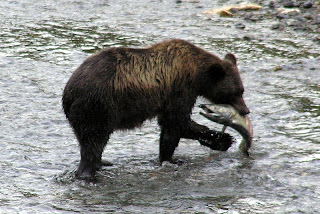
Shortly after the bear with cubs left, another grizzly showed up. He fished awhile, and there is a picture of a bear catching a fish, then he left, and soon another bear showed up – and so it went for several hours. I gather from talking to the ranger, that usually the bears avoid each other, and don’t like to be within sight of each other, so usually we will see just one bear, or a mother with cubs, at a time. There are not always bears at the viewing platform, so sometimes people wait several hours until the bears show up. Early morning and late evening seems to be the best time. We have not seen black bears, only grizzlies. The grizzly bears chase he black bears away. However there are black bears that come around the viewing area. Usually they try to stay in the bushes, and relatively out of sight.
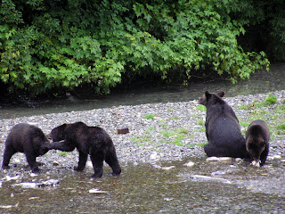
Just this evening we went over to pay a final visit to the bears. We were pleased to see the mother bear and her three cubs again. The cubs entertained us with their antics. Two of the cubs would get on their hind legs, box and cuff each other, then wrestle, until one cub forced the other to the ground and then they would wrestle on the ground. Meanwhile the other cub was lying on his/her back, playing with his/her toes.

Watching the bears is interesting. In the creek the salmon are spawning. The side of the creek is littered with dead “spawned –out” fish. Usually the bears will not eat these, although occasionally they will take a bite or two out of a dead fish, and sometimes, but not often, a bear will eat the dead fish … perhaps these are fish that recently died, and have not spoiled. When the bears fish, they will usually get in the middle of the creek and “herd” the fish upstream or downstream and then lunge in about half the time get a fish. Usually they will take the fish to shore and devour it, eating the skin and the flesh on each side. One bear we saw caught three fish, but threw away the first two after just a couple of bites. We were told that the bears sometimes just want to eat the eggs from the female fish, but I am not sure if this is true.

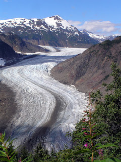
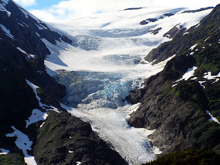
Yesterday we took a drive up a nearby mountain to see the glaciers. There are two important glaciers up there, Salmon Glacier (picture on the left) and Brendan Glacier (picture on the right). It was interesting to see the obvious flow marks in the glacier, and to see that far back, the glacier is on top of mountains. Although this is the middle of August, there are a lot of remains of snow from winter. I doubt if all the snow will be melted, before it begins to snow again.


Fall is definitely in the air here. The temperature frequently gets down into the mid 40’s. On the way down, on the highway, we noted that the shrubs and grasses on the side of the road are turning yellow. Although we are father south, it is certainly obvious, that the nights are getting longer, the days shorter. Here in Stewart, leaves are just beginning to fall. Certainly soon it will be time to go south, and in fact, we will start that way tomorrow morning.

Wednesday, August 22, 2007

On the Road Again, August 21, 2007

On Sunday, we drove up over White Pass, sight-seeing and trying to get a glimpse of the “Dead Horse Trail”, used by the Klondike stampeders. The drive was beautiful, climbing up from sea level to over 5,000 feet in a space of 12 to 15 miles. The road parallels the old trail for the first 5 or 6 miles, and then diverges. We could also get a good view of the narrow gauge railroad bed across the valley.

Once on top of the mountain, on the other side of the pass the country was wild and rough looking tundra, with lots of little ponds and brooks.

On Monday, we broke camp. And again climbed the mountain, and went through the pass eventually to the Yukon Territory. We passed through indescribably beautiful countryside. First, we saw large mountain lakes, five to ten miles long, and a quarter to three quarters miles long, nestled in valleys between high rocky mountains with shear cliffs. As we progressed, the terrain remained the same --- lakes in the shadows of mountains, but the forest of spruce instead of tundra.

Monday night, we are camped in a Provincial Campground, in the woods by a lake. It was beautiful and pleasant to get out in the country away from crowded RV, side by side as we had in the last few campgrounds.

Tuesday we continued down the Alaska Highway to a campground near the Cassiar Highway. The Cassiar Highway is the other road north through British Colombia, to the Yukon Territory, connecting up with the Akaka Highway near the BC-YT border. It runs west of the Alaska Highway, and has a reputation for not being as well maintained. Much of it was gravel until recently, and there is still a 50 mile length of gravel road I hear. We are somewhat apprehensive, as there have been reports that the highway has collapsed in landslides in several places. Local reports are that those have mostly been repaired, and in any event the highway is open all the way.

The Cassiar Highway is said to pass through wild forest and mountains, and we anticipate an adventurous ride, with lots of beautiful scenery.

Fall here is definably in the air. The leaves on shrubs and grass on the side of the road have turned to a golden color. The air is crisp, and evenings are pretty chilly. Pretty soon, Florida is going to sound pretty nice!

Sunday, August 19, 2007

Haines to Skagway, Aug 19, 2007

We put our RV, car and ourselves on the ferry and took a one hour-trip of about 15 miles, going from one branch the fjord where Haines is located, to another branch, where Skagway is located.

Below are a couple of pictures from Haines. First, please see a picture of me in front of the Hammer Museum, which I described in an earlier posting. We thought the huge hammer was pretty interesting!

There are many eagles in Haines, and even more in the winter, so we understand. I believe they winter here because the river flowing into Haines does not freeze, and is a source of fish for the birds. We saw eagles sitting on posts in the harbor, and in trees on the main street.

Haines and Skagway are about the same size, but are very different. An occasional cruise ship stops in Haines -- I think two ships, for a one-day stay, each, when we were there. Skaqway is visited by many cruise ships. There were four in port the day we arrived. Consequently there are surges of tourist in the streets, and many shops opened which cater to tourists. One day the street is crowded, the next day relatively deserted, depending how many cruise ships are in port.

Skagway and the nearby former town of, Dyea (pronounce Dii ee, rhymes with "pie see"), were the beginning of the two major trails over the coastal mountains to Whitehorse, and then by river to the Klondike.

The Chilkoot Trail started in Dyea. In 1898, Dyea had a population of 8,000. In 1903, when the gold rush was over, it had a population of 3. Now the town is gone, and is nothing but cellar holes, rotted timbers and pilings and forest. Nevertheless, the former town is now a National Park, and I suppose is an extension of the Chilkoot Trail National Park. The National Park has an interpretive ranger, who gave us a delightful tour of the old town site. We certainly got a impression of what life must have been like there in the late 1890's.

The Chilkoot Trail, is the trail frequently shown in movies and documentaries. The entire trail is a National Park. The trail was 33 miles, and was the shortest route to Whitehorse and to the Kondike. We started a small hike on the trail (See picture of "Sourdough Dan"). We found he trail started with steep climbing. We wondered how the stampeeders did it, and learned that they usually went in the winter, and traveling was actually easier in the winter. The trail follow a river, and when frozen, the men could pull sleds full of goods on the river ice. The "Scales", the area which has been so frequently photographed of a single file of men carrying their goods on the final trek over Chilkoot Pass, while difficult, is said to have been easier in the winter, because the trail goes over huge boulders, which are covered with snow in the winter. There steps are cut into the ice, upon which the would-be miners trekked up single file.

The miners were required by the Canadian Mounties to carry about a ton of goods, so they could survive a year. They were checked when they crossed the border, at the top of the pass -- the border between Alaska and Canada. This required many trips, caching the supplies, and returning for more. Later, tramways were built, offering the option of ferrying the goods. However, the Chilkoot Trail was the poor man's trail, so many stampeeders carries all their supplies over on their backs, repeating their trips many times.

On our return to Skagway, we saw a bear at the side of the road eating berries. There is a picture here of the bear standing on his back legs. The bears seem to eat an immense amount of leaves, when they eat the berries. We now are getting adept to identifying bear scat on the trail,and can even tell if it is fresh (Caution, Bear Ahead!) or four hours old (Wot, me worry?)

Today we will take the road up to look at White Pass. White Pass is the other Gold Rush route to Whitehorse. White Pass is lower than Chilkoot Pass, the trail longer than the Chilkoot Trail. The trail could be transversed with horses. However, the trail was so steep and narrow, and became so muddy, and the stampeeders in such a hurry, that, it became known as the "Dead Horse Trail". There are many photographs of dead hoses lying along the trail.

Later a railroad was built up over White Pass. While the railroad was completed after the gold rush has subsided, it became for many years the chief route for supplying the Klondike and Dawson City, with good being transported from
Seattle to Skagway by ship, then Skagway to Whitehorse by rail, and the Whitehorse to Dawson city by steamboat on the Yukon River.


Valdez, AK and Haines, AK; posted 8/19/2007

These pictures are somewhat out of the order from which they were taken and and from the events described in the postings.

The first picture shows the edge of a glacier, we saw on our boat trip out of Valdez. You can get an idea of the size of the glacier from the excursion boat floating in front of it.

The next picture show seals on an iceberg, floating next to the glacier. Seals are commonly seen here on almost anything floating out in the water, such as buoys and icebergs.

The next picture is of a black bear (that is really brown, but they are called black bears). Black bears are distinguished from grizzly bears by the absence of a hump.

The ocean picture is of a typical fjord, as seen from a boat. These are beautiful, often the cliffs soar up to snow- or glacier-covered mountains. There are many glacier-fed waterfalls; a typical one is seen on the fjord in the picture.

The next picture is of a grizzly bear. See the hump. This bear is fishing for salmon, but he is a lazy bear, so several times we saw him eating the remains of salmon, that had been filleted by fishermen.

The next picture is of a scenic lighthouse, we saw on our boat trip to Juneau. Finally there is a whale's tail, as he or she dives. They usually reappear again in about six to ten minutes.


On the Road from Dawson City, YT to Eagle, AK; Posted 8/19/2007


The picture below is of the bluffs on the Yukon River at Eagle, Alaska. The town was originally named for the eagles that soared on the bluffs. Note how big and wide the Yukon river is here. It reminds me of the Mississippi,back in the lower 48.

The picture on the right is of fireweed, on an old burn on the road to Eagle. There is a lot of very colorful fireweed up here, but it was especially beautiful on this road.


The picture on the left is of a family of caribou, one of many we saw on the trip to Eagle. Apparently the herd was migrating, an uncommon event in the summer -- probably to escape forest fires. We saw perhaps 7 or 8 groups of animals, ranging from suckling young (yes, we saw one nursing.), yearlings and mature males, and females in groups and also traveling alone.


Bears are always a concern, as you can see in the picture we title, "Bear Paws".