Friday, August 28, 2009

Moving On, Aug 28, 2009


We stayed at Saint Maxine du Mont Louise, the campground mentioned in our next-to last posting, for a couple of days. The RV Park has quite a few sculptures, made from wood and concrete, throughout the park. I have included pictures of two other sculptures which are artistically superior to the miner, although perhaps less novel. The first is of a horse’s head anchored to a large wooden chain. The second is a life-sized wooden statue depicting a worker cleaning a fish – I suppose in honor of the codfish industry,

Madeline spent a lot of time on the beach – first looking, with little success, for shells, and finally collecting sea glass. Much of the glass was of a greenish hue – from old coke bottles, I think, but who knows? It is quite attractive. There was also some white and clear sea glass. A rarer find was brown and blue. The fact that blue was rare is interesting --- indicating I suppose that little cobalt-blue glass is made any more.

A cold front must have moved in on Tuesday night as it grew very cold and terribly windy. We moved west on Wednesday, having a pretty ride down the coast. ( The posting of Aug 27 was on Wednesday evening.)On Thursday we continued our trip. We made one interesting stop at the small city of Rimouski. There were several museums, there --- one of a famous ship-wreck, The Empress of Ireland that went down in 1914, taking over a thousand lives. There was also a lighthouse with a museum in the light housekeeper’s home, and of all things a beached submarine (sous-marin), The Onondaga. When this boat was decommissioned it was purchased for display. After some difficulty, the vessel was eventually brought on to land where it is now a museum. We took a few pictures, but due to time and cost decided to forgo visiting the museum, and continued on.

The trip down the Saint Lawrence was very nice. Every five to seven miles we would come into a small village, with the requisite church, usually a small grocery store, and perhaps a restaurant or two. The style of the houses seems unique to us. Many of the houses are square. A typical house will have a single dormer right in the middle of the front roof. It is not uncommon to see dormers on three or four sides of the houses, Tall rather narrow window are frequently seen in houses, sometimes paired. Most houses have shutters, frequently painted in bright and cheerful colors. The color of the houses is also unique with many houses of bright colors such as red, yellow, green, or even purple, with brightly colored roofs. The homes tend to be freshly painted, and in general seem in better repair, than we are accustomed to see in the US.

There are many farms, -- small, I suppose, by US standards. We see hay out drying, and cows in the field. It seems at times as though we are back to the 1950’s in the US, with many small, active farms. While I am sure they have their share of problems here in Quebec, one does not see the obvious signs of poverty, to which we have become accustomed --- that is no falling-down barns, trailer-homes in poor repair, nor junk cars in the field.
We are now in the small town of Saint-Roch-des Aulnaies, which is on the Saint Lawrence. We will likely stay here for the weekend, and visit Quebec City next week.

Thursday, August 27, 2009

Gaspe Peninsular III, Aug 27, 2009


Yesterday it turned cold with a blustery and strong wind. I guess fall has arrived in this part of Canada. We spent most of the day driving east and are now in the little town of Sainte -Flavie. This town is frequently referred to as the "Gateway to the Gaspe". We are in a small RV Park out of town, but next to a restaurant. I guess the summer tourist "season" is considered over. The people said , "Oh just come in to use the Internet, anytime. We are relaxed now, The season is over."

We are parked facing the Gulf of the Saint Lawrence, making this in some ways an attractive campsite, but perhaps a little primitive.

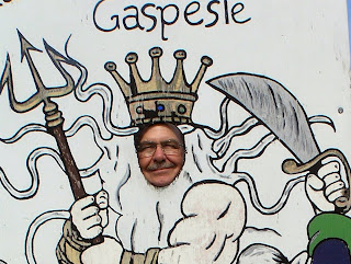
Two pictures here; One a very nice sunrise, that Madeline took at Perce. The other a gag picture on a day i felt like a king.


Monday, August 24, 2009

Gaspe Peninsular II, Aug 24, 2009


Aug 24, 2009

Since our last posting we have traveled a few miles, viewing the extreme east end of the Gaspe Peninsular. We are now on the north side on the Gulf of the Saint Lawrence River. We have had a few anxious moments. First we were concerned about Hurricane Bill, which seemed to be headed toward us --- due to arrive yesterday. That concern turned out to be unjustified. We had a little light rain on Saturday night, and a somewhat overcast skies yesterday morning, and that was it. The hurricane turned east and pretty much missed us completely. The other concern has been that our levelers are not working. They do not retract properly ,and we have are concerned that we will be stuck with levelers down, unable to move – in a French-speaking town, miles from RV repair facilities, no telephone or Email! We finally did get through via Email to learn how to make temporary repairs. Still it is a source of anxiety and tension every time we set up or get ready to leave.

As mentioned above, we spent a couple of days at the town of Perce. This pretty little town is on the east end of the Peninsular. The most important feature is a long thin rock wall out in sea with a hole at bottom of the wall towards the end. You can see this icon of the Gaspe Peninsular in the first picture, with a second picture taken from the dock at Perce, with a beautiful woman in the foreground.

Perce was, at one time, a fishing village, but it seems now mostly devoted to tourists. There are series of buildings that once were devoted to the cod fishery and the sun-dried cod business, discussed in our last posting. In one of these was a very nice art exhibit featuring two or three local artist. Unfortunately we can’t recall the names of the artist, but I have included a photo of a painting of fishing boats, to give you an idea of the exhibit.

We move on along the peninsula and stayed a couple of nights near the Forillon National Park. This park is on the north side of the Bay of Gaspe. It has mountains hiking trails, beaches, and rocky cliffs overlooking crashing waves. The northern end of the Appalachian Trail ends here. Much of the park is only accessible by hiking or biking. We took a short hike along the cliffs overlooking the sea. We visited a museum that was once a general store serving the residents and fisherman in the late 1800’s and early 1900’s. The store in many ways reminded me of the general store operated by my family in my youth (the middle 1900’s, now I think if it!) We also visited a museum of what was once the home of a local fisherman. It was an interesting house, with four bedrooms upstairs, as well as a sewing room in an attic, over the kitchen. Of course it was heated with woodstoves, lit with kerosene lamps. There was a barn with room for a few chickens, two or three cows, and a stall for a horse. We were told that food was supplemented in the winter by trapping and hunting. These families survived by fishing and substance farming. The fishing catch was cod, which was then sundried as previously described in an earlier posting. The dried cod not reserved for personal use, was traded at the store for food, clothing and fishing gear. The dried cod traded at the store eventually ended up at one of the large fish export companies that used cod dried by local fisherman to supplement the cod that they processed themselves for export.

As we moved on, we traveled down the Gulf of the Saint Lawrence. At Cape Rosieres we photographed a very handsome light house overlooking the Gulf. The views along the north side of the Peninsular are striking. The road winds along the cliffs and beaches of the sea, and then suddenly swerves up into the mountains, where there are forest and beautiful little lakes, and then suddenly swerves down into little fishing villages, with ever-present church with a steeple. The churches are particularly beautiful --- each church having an individual style – sometimes in architecture sometimes in color. The final picture shows a typical village taken from the top of a hill overlooking the sea. You can see the church, and if you look carefully, in the background, you can see a road winding down out of the mountains.

Yesterday afternoon, we came to Saint Maxime du Mont Louis. We drove down to the dock and watched a boat come in with three fishermen on it. Apparently they came in mostly for more bait. Madeline starting talking to one of the fishermen was given a gift of five sea urchins. She did not know what exactly to do with them, so they were left on the dock. This is a beautiful little town, and today is a beautiful sunny day so we may stay here a day or two.

Wednesday, August 19, 2009

Along the Southern Coast of the Gaspe Peninsular; Aug 19, 2009; Paspebiac, Quebec

Yesterday we made our way several miles up the southern coast of the Gaspe Peninsular. We made one stop to visit a museum devoted to history of the Arcadians in Quebec. This story has been told in Longfellow’s poem Evangeline (I wonder of kids still read Longfellow’s poem in school?). The Arcadians were emigrants from France and originally lived in New Brunswick. The British fearing the loyalty of these French speaking people, probably also disliking their fierce Catholic religious beliefs, forced a Diaspora of the Arcadians. The Arcadians eventually immigrated to various parts of the world, including the Gaspe peninsular as well as southern Louisiana, where they became the Cajuns. It is interesting to reflect that forced expulsion and attempts to destroy a culture have been going on for centuries.

Our next visit to a museum devoted to the drying of cod fish --- an important industry in this area in the late eighteenth and early nineteenth centuries. Codfish was most important fishery up until recent times. The process of drying fish was quite primitive. The fish were “headed” and filleted at dock-side. Then the fillets were salted down in tubs for several days. Following this the fillets were placed outdoors on racks for drying in the sun. In some cases a shelter was fashioned over the racks to protect from rain. Every evening the fish were taken of the racks and stored overnight skin side up, and then placed on the racks for drying again the next day. Three or four days were required for drying. Once the fish were dried they were placed in hogshead barrels. A press was applied to maximize the fish in each barrel. The barrels of dried salted fish then were ready to be shipped. The dried salted fish was exported to various markets all over the world, including the Basque region in Spain, Brazil, and curiously enough was the Caribbean, were it was fed to slaves.

The cod fishery, as impossible as it might seem, was essentially fished out in the twentieth century --- ruining the economy of many places including Newfoundland. There is a lesson to be learned -- that a resource – be it fish, timber, oil, or even climate -- can be destroyed. Claims that the economic costs of regulation would be destructive of jobs, etc, etc, prove to be short-sighted --- as an industry disappeared the jobs are lost forever.

From Maine to Canada, Aug 18, 2009

I did not get to tell about the salmon cages we saw in the Bay of Fundy. Farmed salmon is quite widespread in the bays of Canada, near the US border.

We walked on down to the shore of the Bay of Fundy in front of Roosevelt’s cottage. We could see off shore a number, perhaps twenty, large salmon cages grouped together about a quarter of a mile off-shore. (See picture.) There were two groups of cages, about a couple of miles separating the two groups. There is some controversy on whether farming salmon is environmentally friendly. Some say it preserves the fishery, others say, since salmon feed is composed predominantly of fish meal, farming salmon is actually destroying a fishery. Others say that intense farming of salmon in the sea is polluting the ocean, while others say that places such as the Bay of Fundy with extreme tidal flows, are an ideal place for farming, since the waste (salmon feces) are washed out to the ocean, where it is diluted to such a degree that contamination is insignificant. Who know how this argument will play out. As in most such arguments, I suspect the truth is in between the two points of view.


On Saturday we left the most easterly point of Maine (and the United States) and started on our journey to the Gaspe Peninsular, planning to take the trip in easy steps. We drove up Route 1 to Houlton, Maine. Northern Maine is sparsely populated, so the area seems quite wild. I found it reminiscent of Alaska and the Yukon Territory in Canada – lots of trees, few houses, and fairly long distances between towns. The roads seem to alternate between stretches of new pavement and stretches of bumpy pavement in poor repair.

We fueled up in Houlton (fuel being about half the price in the US compared to Canada), and crossed the border into New Brunswick. We continued north on a wonderful four-lane Canadian highway, and spent the evening in New Brunswick. The next day we arrived in the province of Quebec.

We have decided to go around the Gaspe peninsular in a counterclockwise direction, so that we will be on driving on the side of the highway towards the sea. On our first day we stayed at a small village, Nouvelle. The south side of the Gaspe Peninsular is quite flat, and I have read it is warmer than the rest of the Gaspe area. The land here is relatively flat, and the sea quite shallow. Here in Nouvelle there are rather large tidal flats. To the north, towards our backs, when facing the sea, are heavily forested mountains.

Yesterday we visited Parc de Miguash, a museum, which is also a national park. This park was developed about twenty five years ago to preserve and the remains of fossil fish and plants found in a cliff. This cliff holds a unique collection of the remains of fish from the Devonian period. The Devonian period was a time when the species of boney and cartilaginous fish expanded, and was the period just before fish developed into land animals. (Apologies to Creationist, but I just don’t see how you can put the existence of these fossils into the Creationist view of life.) There are many species of fossil fish that were deposited during the Devonian period. Apparently conditions were just right so the fish sank in the mud, which eventually turned into shale. Many of the fossils were preserved intact, to such a degree that fossilized nerves and blood vessels can be seen. I was surprised to learn that the current view is that fish probably developed lungs to breathe air and limbs, long before they emerged on land. The limbs that were developed were used for swimming, initially, not walking or crawling.

More Maine travels


These postings are a little late, as we are now in Quebec and Internet is not readily available.

I mentioned in my last posting that we were having blueberry muffins almost every night, while camping near Bar Harbor, thanks to a low-bush blueberry patch right next to the campground. (Madeline said she had never picked blueberries before.) Please see the picture of the blueberries, just to get an idea how thick they were. I think low-bush wild blueberries are the most flavorful of all blueberries.


We left Mount Desert Island several days ago and started our journey north and east toward Quebec. We changed our plans and decided to go all the way east to Eastport. We reached that area with an easy days driving and stopped to visit the area for a day. We went down to the harbor in Eastport, and were greeted by a statue of and tough looking cod fisherman – see the attached picture. As I said in an earlier post there were a number of people fishing, with the youngster seeming to be catching the most. The catch of the day was mackerel.


The next day we drove to Lubec, a small fishing town, where my father taught school. He and my mother lived in a rented house there. There is an old brick building that looks as if might have once been a small school. When I have time, I will research this.

Then we dove a short distance over a short bridge over to Franklin Roosevelt’s summer “cottage” on Campobello Island. Campobello Island is actually in New Brunswick, Canada, but is only several hundred yards from the United States. Roosevelt’s summer home is now an international park, on about 2800 acres, mostly a natural area with trails. The house is open to visitors. A picture of the “cottage” is attached. The building itself is quite large, and could only be termed a “cottage” as a term used by the rich and super-rich in the early twentieth century to describe their summer mansions. The Roosevelt cottage, although large, was furnished rather sparsely, and while tastefully furnished, certainly not lavishly. In 1929, while vacationing there Roosevelt came down with polio and left the island on a stretcher, his life changed forever. His recovery and subsequent submission into politics, prevented him from returning for nearly twelve years, and then for only three brief visits.


While in the area,, we drove to West Quoddy Head Light – a handsome red-and-white striped light house in South Lubec and also the eastern most point in the United States ( Of course, we will be travelling up to the Gaspe Peninsular, much further east – so we were only minimally impressed!) See the accompanying picture of this very handsome light house and also a picture of a plate announcing its extreme eastern geographical location


Wednesday, August 12, 2009

Maine Times, Aug 19, 2009


From New Hampshire, we moved on to the Maine, en route to Quebec Provence. We stopped in Turner, Maine to visit with my cousin, Horace. (Horace, aka as Sonny in much earlier days) is my mother's nephew.) Horace is is an ardent genealogist and has done extensive research on our family tree -- tracing some branches back as far as the Mayflower. Madeline and I spent a day with Horace, visiting cemeteries and various areas where my mother and her parents lived as a child.

The picture on the left, is what was once the Horace True farm on Upper Street Road. My mother visited here frequently when she was a girl, and her aunts used to live here.

This barn was on the farm where Charles Moody lived. It is in Turner, Maine. There is a cellar hole nearby where the house was. This is the farm my where my mother was born, and raised until the family moved to Auburn..

Some of my ancestors moved from Massachusetts in the early 1800's, settling in Minot, Maine. The original house they settled in was on top of a hill and the house and barn have since disappeared.

However one house of an early relative is still standing, and there is a picture of it above. Note the narrow windows and the window over the front door -- characteristics of homes of that early period.
After sending a delightful two days with my cousin we moved on to Arcadia National Park on Mount Desert Island. We camped near Bar Harbor. We had beautiful weather, while we were there. We spent some time examining the rocky shore, and drove up Mount Cadillac Mountain. The harbors, with the fishing boats and pine trees on the rocky shores are beautiful. On the left is a typical scene from Southwest Harbor.
There are a number of lighthouses around the Island. There is a nice picture that Madeline took of the lighthouse at Bass Harbor.

We had to wait to get a new water pump delivered from the RV factory in Alabama. This was a good place to do it, with the beautiful surroundings and nice neighbors. We were parked next to two RVs belonging to fellow Escapees, and met another family, that were just beginning to RV half time. Nearby was a patch of wild, low bush blueberries. We were able to pick enough in about 15 minutes to make blueberry muffins every night! Thanks, Debbie, for the great recipe in your family cookbook.
We are now in a campground near Eastport, Maine. Last evening we went down to the dock at Eastport. the tides are truly high here. The floating docks with the attached boats were probably fifteen feet below the piers. A number of people were fishing with poles off the piers. As is usually the case twelve-to-fifteen-year-old boys were catching most of the fish --- reeling in mackerel three at a time on triple-baited lines.
New England Yankees (meaning "natives" from Maine, New Hampshire, and Vermont) have always had a peculiar relationship with out-of staters -- disliking them as a being intrusive, but of course, like any individual out-of stater they know. There was an interesting article in a local paper, The Fisherman's Voice, complaining about having to wait in line at grocery stores, while rich out-of-state people wait for their VISA card to clear. Anyway -- there is a new name for out-of state people --- "picked ears". Read this quote -- it is kind of funny.
"Lo and behold, someone discovered the charge card. Now we get picked ears everywhere. They leave home with a ten dollar bill in their pocket and a clean shirt in a bag. They stay a month and they never change either one. You come in off the water after a hard days fishing and stop at the local store on your way home. There they are, picked ears ten deep at the cash register trying to palm off some kind of charge card that half the time the cashier never heard of.
They stand there, trying one card after another while your beer is getting warm and your temper is getting hot. "
Picked ears -- that is a new one to me. I wonder where it came from.


Tuesday, August 11, 2009

Greenfield Fun, Aug 11, 2009

Today, I am going to play a little catch-up. Actually we have left Greenfield, N.H (my home-town), and come to Maine -- we are now down east near Bar Harbor. But more about that in my next posting. I want to talk about out time in New Hampshire.

We came across an interesting set of structures, the Yankee Siege, in South Greenfield, across from the Yankee Farmer produce stand. For those who have not been to Greenfield for decades, this set of structures is on the site of the old Robbins home, the once the rather ugly house that was faced with field stones (i.e.rocks).

The Yankee Siege is a name given to a trebuchet, built by a dentist (who owns the produce stand) and his friends. A trebuchet is a type of catapult used in the siege of castles in medieval times. Below, is a picture of a placard on the bulletin board explaining how the trebuchet works. Basically it has a huge arm, to which is attached a sling. The trebuchet is energized with a counter weight.

A picture of the trebuchet (without the sling) is shown below.

The trebuchet is used every fall to sling pumpkins at a target castle. I am not clear how the distance is determined, but I suppose there must be some type of adjustment of the counterweight, or perhaps on the length of the ropes holding sling.


The picture to the left is of the target, a mock castle, some distance (perhaps 500-800 yards) from the trebuchet. Note the pumpkin patch in front of the castle. Late in October, the trebuchet is put in action --- firing pumpkins at and hopefully hitting the castle.
There are number of hobbyist who have built trebuchet, and this has become a competitive event --- the competition is called, Punkin Chunkin. I think the point of the competition is to see who can throw a pumpkin the furthermost. This years Punkin Chunkin is held in Nov 6, 7, and 8, near Bridgeville, Delaware.
For more information on the Yankee Siege, go to http://wwwyankeesiege.com/
There are other postings if you look up Yankee Siege, and Punkin Chunkin.
Another nice time we had in Greenfield was a gathering of the clan at my cousin's, Ginny's home. Some of her family was there, as well as children and grandchildren of my cousin, Muriel, and of course, my cousin, Peter. (Peter is now the volunteer firemen in Greenfield with the most experience in the volunteer fire department.)
To the left is a picture of three formerly deaf, but coclear implanted cousins: Ginny, Dan (me) and Muriel.